Alexandra geodata
Alexandra (Victoria) is a populated place; located in Australia in Australia/Melbourne (GMT+11) time zone. With population of 2,575 people, there are 2517 cities with bigger population in this country. Compared to other cities in Australia, 82% of cities are located further ↑North; 58.6% of cities are located further →East and 83.4% of cities have lower elevation than Alexandra. Note1


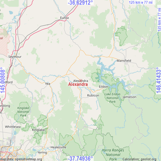
Alexandra GPS coordinates[2]
37° 11' 28.752" South, 145° 42' 40.32" East
| Map corner | latitude | longitude |
|---|---|---|
| Upper-left | -36.62912°, | 145.00808° |
| Center: | -37.19132°, | 145.7112° |
| Lower-right: | -37.74936°, | 146.41433° |
| Map W x H: | 124.6×124.6 km | = 77.4×77.4mi |
| max Lat: | -10.58257° ⇑82% North |
| Alexandra: | -37.19132° |
| min Lat: | ⇓18% South -43.31423° |
| min Long | Alexandra | max Long |
| 113.53327° | 145.7112° | 153.61246° |
| W 41.4%⇐ | ⇒58.6% E |
Elevation
Elevation of Alexandra is 222 m = 728 ft, and this is 100 m = 328 ft above average elevation for this country.
| Max E: |
1715 m = 5627 ft | 16.6% |
| Alexandra | 222 m 728 ft | |
| Avg. | 122 m = 400 ft | |
Min E: |
-2 m = -7 ft | 83.4% |
See also: Australia elevation on elevation.city.
Geographical zone
Alexandra is located in South temperate zone (between Tropic of Capricorn and the Antarctic Circle). Distance of this Southern Tropic circle is 1529.4 km =950.3 mi to North.| Distance of | km | miles | from Alexandra |
|---|---|---|---|
| Equator | 4135.3 | 2569.6 | to North |
| Tropic Capricorn | 1529.4 | 950.3 | to North |
| Antarctic Circle | 3265.9 | 2029.3 | to South |
| South Pole | 5871.8 | 3648.6 | to South |


Nearby cities:
15 places around Alexandra: (largest is in red/bold)
• Avenel
53.3 km =33.1 mi,  307°
307°
• Bonnie Doon
23.8 km =14.8 mi,  35°
35°
• Broadford
58.7 km =36.5 mi,  268°
268°
• Chum Creek
50.1 km =31.1 mi,  203°
203°
• Eildon
18.4 km =11.4 mi,  104°
104°
• Euroa
50 km =31.1 mi,  345°
345°
• Flowerdale
37 km =23 mi,  244°
244°
• Healesville
54.2 km =33.7 mi, 198°
• Kinglake
50.2 km =31.2 mi,  220°
220°
• Kinglake West
52.2 km =32.4 mi,  234°
234°
• Mansfield
36.9 km =22.9 mi,  65°
65°
• Merrijig
48.8 km =30.3 mi,  77°
77°
• Seymour
53.9 km =33.5 mi,  289°
289°
• Tallarook
55.2 km =34.3 mi,  281°
281°
• Yea
25.2 km =15.7 mi, 265°
Sources, notices
• [Note1] Compared only with cities in Australia existing in our database
• [Src1] Map data: © OpenStreetMap contributors (CC-BY-SA)
• [Src2] Other city data from geonames.org with taken over terms of usage.
• [Src3] Geographical zone / Annual Mean Temperature by Robert A. Rohde @ Wikipedia
