Kakadu geodata
Kakadu (Northern Territory) is a section of populated place; located in Australia in Australia/Darwin (GMT+9.5) time zone. With population of 872 people, there are 4016 cities with bigger population in this country. Compared to other cities in Australia, 98.3% of cities are located further ↓South; 87% of cities are located further →East and 90.1% of cities have higher elevation than Kakadu. Note1


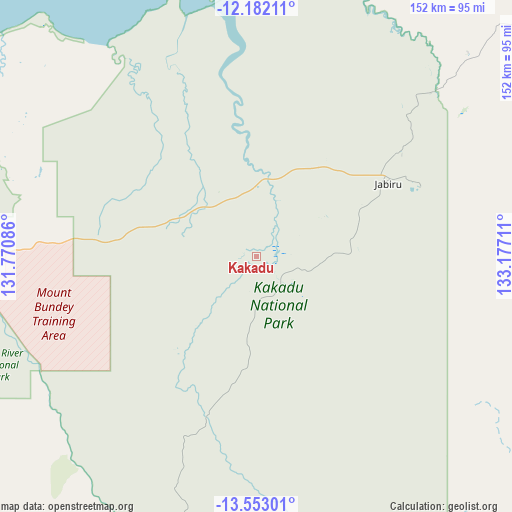
Kakadu GPS coordinates[2]
12° 52' 6.6" South, 132° 28' 26.328" East
| Map corner | latitude | longitude |
|---|---|---|
| Upper-left | -12.18211°, | 131.77086° |
| Center: | -12.8685°, | 132.47398° |
| Lower-right: | -13.55301°, | 133.17711° |
| Map W x H: | 152.4×152.4 km | = 94.7×94.7mi |
| max Lat: | -10.58257° ⇑1.7% North |
| Kakadu: | -12.8685° |
| min Lat: | ⇓98.3% South -43.31423° |
| min Long | Kakadu | max Long |
| 113.53327° | 132.47398° | 153.61246° |
| W 13%⇐ | ⇒87% E |
Elevation
Elevation of Kakadu is 9 m = 30 ft, and this is 113 m = 371 ft below average elevation for this country.
| Max E: |
1715 m = 5627 ft | 90.1% |
| Avg. | 122 m = 400 ft | |
| Kakadu | 9 m = 30 ft | |
Min E: |
-2 m = -7 ft | 9.9% |
See also: Australia elevation on elevation.city.
Geographical zone
Kakadu is located in South Torrid zone (between Equator and Tropic of Capricorn). Distance of this Southern Tropic circle is 1175.1 km =730.2 mi to South.| Distance of | km | miles | from Kakadu |
|---|---|---|---|
| Equator | 1430.8 | 889.1 | to North |
| Tropic Capricorn | 1175.1 | 730.2 | to South |
| Antarctic Circle | 5970.3 | 3709.8 | to South |
| South Pole | 8576.2 | 5329 | to South |


Nearby cities:
15 places around Kakadu: (largest is in red/bold)
• Acacia Hills
146.4 km =91 mi,  273°
273°
• Batchelor
157.7 km =98 mi,  262°
262°
• Bees Creek
156.8 km =97.4 mi,  281°
281°
• Berry Springs
159.4 km =99 mi, 276°
• Coolalinga
160.1 km =99.5 mi, 283°
• Douglas-Daly
159.6 km =99.2 mi,  229°
229°
• Girraween
154.3 km =95.9 mi, 284°
• Gunbalanya
87 km =54.1 mi,  45°
45°
• Herbert
147.1 km =91.4 mi, 284°
• Howard Springs
160.5 km =99.7 mi, 284°
• Humpty Doo
148.4 km =92.2 mi, 282°
• Jabiru
45 km =28 mi,  60°
60°
• Marrakai
108.5 km =67.4 mi, 276°
• McMinns Lagoon
155.7 km =96.7 mi, 283°
• Virginia
161.5 km =100.4 mi, 283°
Sources, notices
• [Note1] Compared only with cities in Australia existing in our database
• [Src1] Map data: © OpenStreetMap contributors (CC-BY-SA)
• [Src2] Other city data from geonames.org with taken over terms of usage.
• [Src3] Geographical zone / Annual Mean Temperature by Robert A. Rohde @ Wikipedia
