Gunbalanya geodata
Gunbalanya (Northern Territory) is a section of populated place; located in Australia in Australia/Darwin (GMT+9.5) time zone. With population of 1,121 people, there are 3675 cities with bigger population in this country. Compared to other cities in Australia, 99.8% of cities are located further ↓South; 86.9% of cities are located further →East and 88.3% of cities have higher elevation than Gunbalanya. Note1


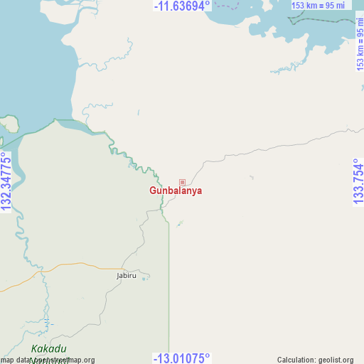
Gunbalanya GPS coordinates[2]
12° 19' 29.064" South, 133° 3' 3.132" East
| Map corner | latitude | longitude |
|---|---|---|
| Upper-left | -11.63694°, | 132.34775° |
| Center: | -12.32474°, | 133.05087° |
| Lower-right: | -13.01075°, | 133.754° |
| Map W x H: | 152.8×152.8 km | = 94.9×94.9mi |
| max Lat: | -10.58257° ⇑0.2% North |
| Gunbalanya: | -12.32474° |
| min Lat: | ⇓99.8% South -43.31423° |
| min Long | Gunbalanya | max Long |
| 113.53327° | 133.05087° | 153.61246° |
| W 13.1%⇐ | ⇒86.9% E |
Elevation
Elevation of Gunbalanya is 10 m = 33 ft, and this is 112 m = 367 ft below average elevation for this country.
| Max E: |
1715 m = 5627 ft | 88.3% |
| Avg. | 122 m = 400 ft | |
| Gunbalanya | 10 m = 33 ft | |
Min E: |
-2 m = -7 ft | 11.7% |
See also: Australia elevation on elevation.city.
Geographical zone
Gunbalanya is located in South Torrid zone (between Equator and Tropic of Capricorn). Distance of this Southern Tropic circle is 1235.5 km =767.7 mi to South.| Distance of | km | miles | from Gunbalanya |
|---|---|---|---|
| Equator | 1370.4 | 851.5 | to North |
| Tropic Capricorn | 1235.5 | 767.7 | to South |
| Antarctic Circle | 6030.8 | 3747.4 | to South |
| South Pole | 8636.7 | 5366.6 | to South |


Nearby cities:
15 places around Gunbalanya: (largest is in red/bold)
• Acacia Hills
215.4 km =133.8 mi,  255°
255°
• Bees Creek
218.1 km =135.5 mi, 262°
• Coolalinga
219.3 km =136.3 mi, 264°
• Girraween
213.5 km =132.7 mi, 264°
• Herbert
206.4 km =128.3 mi, 263°
• Howard Springs
218.7 km =135.9 mi,  265°
265°
• Humpty Doo
209.8 km =130.4 mi, 262°
• Jabiru
45 km =28 mi,  211°
211°
• Kakadu
87 km =54.1 mi,  225°
225°
• Maningrida
131.7 km =81.8 mi,  76°
76°
• Marrakai
176.9 km =109.9 mi,  254°
254°
• McMinns Lagoon
215.8 km =134.1 mi, 263°
• Milingimbi
204.5 km =127.1 mi, 83°
• Ramingining
204.3 km =126.9 mi,  90°
90°
• West Arnhem
110.1 km =68.4 mi, 84°
Sources, notices
• [Note1] Compared only with cities in Australia existing in our database
• [Src1] Map data: © OpenStreetMap contributors (CC-BY-SA)
• [Src2] Other city data from geonames.org with taken over terms of usage.
• [Src3] Geographical zone / Annual Mean Temperature by Robert A. Rohde @ Wikipedia
