Jabiru geodata
Jabiru (Northern Territory) is a populated place; located in Australia in Australia/Darwin (GMT+9.5) time zone. With population of 1,540 people, there are 3249 cities with bigger population in this country. Compared to other cities in Australia, 98.5% of cities are located further ↓South; 86.9% of cities are located further →East and 62.8% of cities have higher elevation than Jabiru. Note1


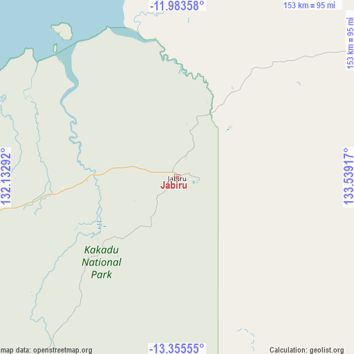
Jabiru GPS coordinates[2]
12° 40' 13.764" South, 132° 50' 9.744" East
| Map corner | latitude | longitude |
|---|---|---|
| Upper-left | -11.98358°, | 132.13292° |
| Center: | -12.67049°, | 132.83604° |
| Lower-right: | -13.35555°, | 133.53917° |
| Map W x H: | 152.5×152.6 km | = 94.8×94.8mi |
| max Lat: | -10.58257° ⇑1.5% North |
| Jabiru: | -12.67049° |
| min Lat: | ⇓98.5% South -43.31423° |
| min Long | Jabiru | max Long |
| 113.53327° | 132.83604° | 153.61246° |
| W 13.1%⇐ | ⇒86.9% E |
Elevation
Elevation of Jabiru is 29 m = 95 ft, and this is 93 m = 305 ft below average elevation for this country.
| Max E: |
1715 m = 5627 ft | 62.8% |
| Avg. | 122 m = 400 ft | |
| Jabiru | 29 m = 95 ft | |
Min E: |
-2 m = -7 ft | 37.2% |
See also: Australia elevation on elevation.city.
Geographical zone
Jabiru is located in South Torrid zone (between Equator and Tropic of Capricorn). Distance of this Southern Tropic circle is 1197.1 km =743.8 mi to South.| Distance of | km | miles | from Jabiru |
|---|---|---|---|
| Equator | 1408.8 | 875.4 | to North |
| Tropic Capricorn | 1197.1 | 743.8 | to South |
| Antarctic Circle | 5992.3 | 3723.4 | to South |
| South Pole | 8598.2 | 5342.7 | to South |


Nearby cities:
15 places around Jabiru: (largest is in red/bold)
• Acacia Hills
186 km =115.6 mi,  265°
265°
• Bees Creek
193 km =119.9 mi, 273°
• Berry Springs
197.6 km =122.8 mi, 269°
• Coolalinga
195.4 km =121.4 mi, 274°
• Girraween
189.5 km =117.7 mi, 274°
• Gunbalanya
45 km =28 mi,  31°
31°
• Herbert
182.3 km =113.3 mi, 274°
• Howard Springs
195.4 km =121.4 mi,  275°
275°
• Humpty Doo
184.6 km =114.7 mi, 272°
• Kakadu
45 km =28 mi,  240°
240°
• Maningrida
166.4 km =103.4 mi,  65°
65°
• Marrakai
147.3 km =91.5 mi, 266°
• McMinns Lagoon
191.4 km =118.9 mi, 274°
• Virginia
196.9 km =122.3 mi, 274°
• West Arnhem
141.5 km =87.9 mi, 69°
Sources, notices
• [Note1] Compared only with cities in Australia existing in our database
• [Src1] Map data: © OpenStreetMap contributors (CC-BY-SA)
• [Src2] Other city data from geonames.org with taken over terms of usage.
• [Src3] Geographical zone / Annual Mean Temperature by Robert A. Rohde @ Wikipedia
