Vank geodata
Vank (Kalbajar) is a populated place; located in Azerbaijan in Asia/Baku (GMT+4) time zone. With population of 1,335 people, there are 163 cities with bigger population in this country. Compared to other cities in Azerbaijan, 65.9% of cities are located further ↑North; 73% of cities are located further →East and 88.6% of cities have lower elevation than Vank. Note1


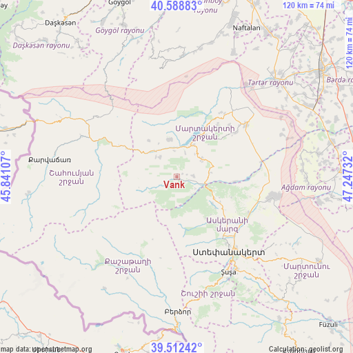
Vank GPS coordinates[2]
40° 3' 9.9" North, 46° 32' 39.084" East
| Map corner | latitude | longitude |
|---|---|---|
| Upper-left | 40.58883°, | 45.84107° |
| Center: | 40.05275°, | 46.54419° |
| Lower-right: | 39.51242°, | 47.24732° |
| Map W x H: | 119.7×119.7 km | = 74.4×74.4mi |
| max Lat: | 41.75259° ⇑65.9% North |
| Vank: | 40.05275° |
| min Lat: | ⇓34.1% South 38.45598° |
| min Long | Vank | max Long |
| 44.84846° | 46.54419° | 50.84003° |
| W 27%⇐ | ⇒73% E |
Elevation
Elevation of Vank is 1031 m = 3383 ft, and this is 648 m = 2126 ft above average elevation for this country.
| Max E: |
2211 m = 7254 ft | 11.4% |
| Vank | 1031 m 3383 ft | |
| Avg. | 383 m = 1257 ft | |
Min E: |
-26 m = -85 ft | 88.6% |
See also: Azerbaijan elevation on elevation.city.
Geographical zone
Vank is located in North temperate zone (between Tropic of Cancer and the Arctic Circle). Distance of this Northern Tropic circle is 1847.5 km =1148 mi to South.| Distance of | km | miles | from Vank |
|---|---|---|---|
| North Pole | 5553.6 | 3450.8 | to North |
| Arctic Circle | 2947.7 | 1831.6 | to North |
| Tropic Cancer | 1847.5 | 1148 | to South |
| Equator | 4453.4 | 2767.2 | to South |


Nearby cities:
15 places around Vank: (largest is in red/bold)
• Askyaran
27.6 km =17.1 mi,  117°
117°
• Ağdam
33.3 km =20.7 mi,  101°
101°
• Barda
61.1 km =38 mi,  53°
53°
• Kerbakhiar
43 km =26.7 mi,  278°
278°
• Laçın
50.5 km =31.4 mi,  179°
179°
• Martakert
29.4 km =18.3 mi, 53°
• Naftalan
55.8 km =34.7 mi,  24°
24°
• Novyy Karanlug
56.2 km =34.9 mi, 120°
• Qaramanlı
61 km =37.9 mi,  38°
38°
• Qırmızı Bazar
54.4 km =33.8 mi,  140°
140°
• Shushi
37 km =23 mi,  151°
151°
• Terter
46 km =28.6 mi, 45°
• Xankandi
31.6 km =19.6 mi, 145°
• Xocalı
26.1 km =16.2 mi,  126°
126°
• İstisu
51.1 km =31.8 mi,  256°
256°
Sources, notices
• [Note1] Compared only with cities in Azerbaijan existing in our database
• [Src1] Map data: © OpenStreetMap contributors (CC-BY-SA)
• [Src2] Other city data from geonames.org with taken over terms of usage.
• [Src3] Geographical zone / Annual Mean Temperature by Robert A. Rohde @ Wikipedia
