Shamakhi geodata
Shamakhi (Şamaxı) is a seat of a first-order administrative division; located in Azerbaijan in Asia/Baku (GMT+4) time zone. With population of 29,403 people, there are 27 cities with bigger population in this country. Compared to other cities in Azerbaijan, 71.9% of cities are located further ↓South; 63.8% of cities are located further ←West and 75.7% of cities have lower elevation than Shamakhi. Note1


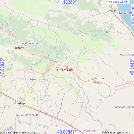
Shamakhi GPS coordinates[2]
40° 37' 53.076" North, 48° 38' 28.932" East
| Map corner | latitude | longitude |
|---|---|---|
| Upper-left | 41.16289°, | 47.93825° |
| Center: | 40.63141°, | 48.64137° |
| Lower-right: | 40.09567°, | 49.3445° |
| Map W x H: | 118.7×118.7 km | = 73.8×73.8mi |
| max Lat: | 41.75259° ⇑28.1% North |
| Shamakhi: | 40.63141° |
| min Lat: | ⇓71.9% South 38.45598° |
| min Long | Shamakhi | max Long |
| 44.84846° | 48.64137° | 50.84003° |
| W 63.8%⇐ | ⇒36.2% E |
Elevation
Elevation of Shamakhi is 687 m = 2254 ft, and this is 304 m = 997 ft above average elevation for this country.
| Max E: |
2211 m = 7254 ft | 24.3% |
| Shamakhi | 687 m 2254 ft | |
| Avg. | 383 m = 1257 ft | |
Min E: |
-26 m = -85 ft | 75.7% |
See also: Azerbaijan elevation on elevation.city.
Geographical zone
Shamakhi is located in North temperate zone (between Tropic of Cancer and the Arctic Circle). Distance of this Northern Tropic circle is 1911.9 km =1188 mi to South.| Distance of | km | miles | from Shamakhi |
|---|---|---|---|
| North Pole | 5489.3 | 3410.9 | to North |
| Arctic Circle | 2883.4 | 1791.7 | to North |
| Tropic Cancer | 1911.9 | 1188 | to South |
| Equator | 4517.8 | 2807.2 | to South |


Nearby cities:
15 places around Shamakhi: (largest is in red/bold)
• Aghsu
21.4 km =13.3 mi,  251°
251°
• Altıağac
35.3 km =21.9 mi,  44°
44°
• Basqal
25.2 km =15.7 mi,  303°
303°
• Divichibazar
69.7 km =43.3 mi,  24°
24°
• Gilgilçay
67.9 km =42.2 mi,  33°
33°
• Hacıqabul
70.7 km =43.9 mi,  158°
158°
• Khyzy
47.8 km =29.7 mi,  49°
49°
• Kilyazi
65 km =40.4 mi,  65°
65°
• Kyurdarmir
52.1 km =32.4 mi,  231°
231°
• Kyzyl-Burun
63.7 km =39.6 mi, 38°
• Lahıc
32.4 km =20.1 mi,  317°
317°
• Mughan
61.1 km =38 mi,  165°
165°
• Qobustan
26.6 km =16.5 mi,  114°
114°
• Sabirabad
70.6 km =43.9 mi,  191°
191°
• İsmayıllı
44.7 km =27.8 mi,  292°
292°
Sources, notices
• [Note1] Compared only with cities in Azerbaijan existing in our database
• [Src1] Map data: © OpenStreetMap contributors (CC-BY-SA)
• [Src2] Other city data from geonames.org with taken over terms of usage.
• [Src3] Geographical zone / Annual Mean Temperature by Robert A. Rohde @ Wikipedia
