Qobustan geodata
Qobustan is a seat of a first-order administrative division; located in Azerbaijan in Asia/Baku (GMT+4) time zone. With population of 3,754 people, there are 120 cities with bigger population in this country. Compared to other cities in Azerbaijan, 61.6% of cities are located further ↓South; 69.7% of cities are located further ←West and 80% of cities have lower elevation than Qobustan. Note1


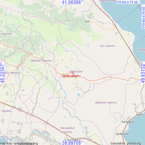
Qobustan GPS coordinates[2]
40° 32' 0.96" North, 48° 55' 41.484" East
| Map corner | latitude | longitude |
|---|---|---|
| Upper-left | 41.06586°, | 48.22507° |
| Center: | 40.5336°, | 48.92819° |
| Lower-right: | 39.99708°, | 49.63132° |
| Map W x H: | 118.8×118.8 km | = 73.8×73.8mi |
| max Lat: | 41.75259° ⇑38.4% North |
| Qobustan: | 40.5336° |
| min Lat: | ⇓61.6% South 38.45598° |
| min Long | Qobustan | max Long |
| 44.84846° | 48.92819° | 50.84003° |
| W 69.7%⇐ | ⇒30.3% E |
Elevation
Elevation of Qobustan is 771 m = 2530 ft, and this is 388 m = 1273 ft above average elevation for this country.
| Max E: |
2211 m = 7254 ft | 20% |
| Qobustan | 771 m 2530 ft | |
| Avg. | 383 m = 1257 ft | |
Min E: |
-26 m = -85 ft | 80% |
See also: Azerbaijan elevation on elevation.city.
Geographical zone
Qobustan is located in North temperate zone (between Tropic of Cancer and the Arctic Circle). Distance of this Northern Tropic circle is 1901 km =1181.2 mi to South.| Distance of | km | miles | from Qobustan |
|---|---|---|---|
| North Pole | 5500.1 | 3417.6 | to North |
| Arctic Circle | 2894.3 | 1798.4 | to North |
| Tropic Cancer | 1901 | 1181.2 | to South |
| Equator | 4506.9 | 2800.5 | to South |


Nearby cities:
15 places around Qobustan: (largest is in red/bold)
• Aghsu
44.7 km =27.8 mi,  275°
275°
• Altıağac
36.1 km =22.4 mi,  0°
0°
• Basqal
51.6 km =32.1 mi,  298°
298°
• Ceyranbatan
61.9 km =38.5 mi,  89°
89°
• Hacı Zeynalabdin
54.2 km =33.7 mi,  79°
79°
• Hacıqabul
55 km =34.2 mi,  178°
178°
• Khyzy
43.5 km =27 mi,  16°
16°
• Kilyazi
51.6 km =32.1 mi,  42°
42°
• Kyzyl-Burun
62.6 km =38.9 mi,  14°
14°
• Lahıc
57.7 km =35.9 mi,  307°
307°
• Mughan
49.2 km =30.6 mi,  190°
190°
• Sanqaçal
60.8 km =37.8 mi,  131°
131°
• Shamakhi
26.6 km =16.5 mi,  294°
294°
• Şonqar
61.5 km =38.2 mi,  112°
112°
• Şuraabad
55.5 km =34.5 mi,  55°
55°
Sources, notices
• [Note1] Compared only with cities in Azerbaijan existing in our database
• [Src1] Map data: © OpenStreetMap contributors (CC-BY-SA)
• [Src2] Other city data from geonames.org with taken over terms of usage.
• [Src3] Geographical zone / Annual Mean Temperature by Robert A. Rohde @ Wikipedia
