Oğuz geodata
Oğuz is a seat of a first-order administrative division; located in Azerbaijan in Asia/Baku (GMT+4) time zone. With population of 6,600 people, there are 98 cities with bigger population in this country. Compared to other cities in Azerbaijan, 85.9% of cities are located further ↓South; 51.9% of cities are located further →East and 73.5% of cities have lower elevation than Oğuz. Note1


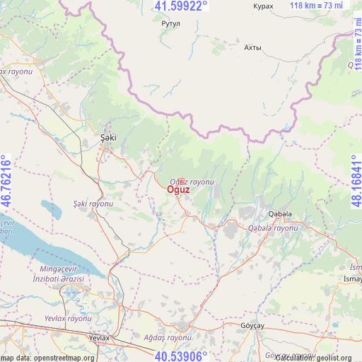
Oğuz GPS coordinates[2]
41° 4' 16.608" North, 47° 27' 55.008" East
| Map corner | latitude | longitude |
|---|---|---|
| Upper-left | 41.59922°, | 46.76216° |
| Center: | 41.07128°, | 47.46528° |
| Lower-right: | 40.53906°, | 48.16841° |
| Map W x H: | 117.9×117.9 km | = 73.3×73.3mi |
| max Lat: | 41.75259° ⇑14.1% North |
| Oğuz: | 41.07128° |
| min Lat: | ⇓85.9% South 38.45598° |
| min Long | Oğuz | max Long |
| 44.84846° | 47.46528° | 50.84003° |
| W 48.1%⇐ | ⇒51.9% E |
Elevation
Elevation of Oğuz is 652 m = 2139 ft, and this is 269 m = 883 ft above average elevation for this country.
| Max E: |
2211 m = 7254 ft | 26.5% |
| Oğuz | 652 m 2139 ft | |
| Avg. | 383 m = 1257 ft | |
Min E: |
-26 m = -85 ft | 73.5% |
See also: Azerbaijan elevation on elevation.city.
Geographical zone
Oğuz is located in North temperate zone (between Tropic of Cancer and the Arctic Circle). Distance of this Northern Tropic circle is 1960.8 km =1218.4 mi to South.| Distance of | km | miles | from Oğuz |
|---|---|---|---|
| North Pole | 5440.4 | 3380.5 | to North |
| Arctic Circle | 2834.5 | 1761.3 | to North |
| Tropic Cancer | 1960.8 | 1218.4 | to South |
| Equator | 4566.7 | 2837.6 | to South |


Nearby cities:
15 places around Oğuz: (largest is in red/bold)
• Aran
64.5 km =40.1 mi,  219°
219°
• Ağdaş
47.2 km =29.3 mi,  179°
179°
• Baş Göynük
40.8 km =25.4 mi,  313°
313°
• Geoktschai
52.3 km =32.5 mi,  153°
153°
• Mingelchaur
48.3 km =30 mi, 224°
• Qax
59.7 km =37.1 mi, 310°
• Qax İngiloy
59 km =36.7 mi, 311°
• Qaxbaş
58 km =36 mi, 313°
• Qutqashen
33.7 km =20.9 mi,  107°
107°
• Samuxlu
67.4 km =41.9 mi,  201°
201°
• Sheki
28.1 km =17.5 mi,  298°
298°
• Ujar
63.4 km =39.4 mi,  165°
165°
• Yevlakh
56.9 km =35.4 mi,  207°
207°
• Çinarlı
63.8 km =39.6 mi, 313°
• İsmayıllı
65.9 km =40.9 mi,  118°
118°
Sources, notices
• [Note1] Compared only with cities in Azerbaijan existing in our database
• [Src1] Map data: © OpenStreetMap contributors (CC-BY-SA)
• [Src2] Other city data from geonames.org with taken over terms of usage.
• [Src3] Geographical zone / Annual Mean Temperature by Robert A. Rohde @ Wikipedia
