Kilyazi geodata
Kilyazi (Xızı) is a populated place; located in Azerbaijan in Asia/Baku (GMT+4) time zone. With population of 3,277 people, there are 122 cities with bigger population in this country. Compared to other cities in Azerbaijan, 81.6% of cities are located further ↓South; 77.3% of cities are located further ←West and 83.2% of cities have higher elevation than Kilyazi. Note1


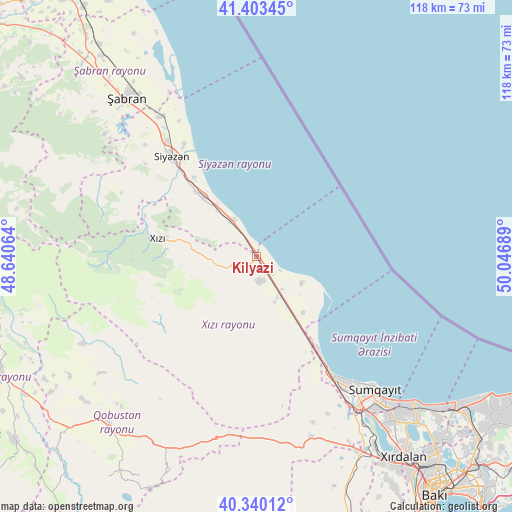
Kilyazi GPS coordinates[2]
40° 52' 26.112" North, 49° 20' 37.536" East
| Map corner | latitude | longitude |
|---|---|---|
| Upper-left | 41.40345°, | 48.64064° |
| Center: | 40.87392°, | 49.34376° |
| Lower-right: | 40.34012°, | 50.04689° |
| Map W x H: | 118.2×118.2 km | = 73.4×73.4mi |
| max Lat: | 41.75259° ⇑18.4% North |
| Kilyazi: | 40.87392° |
| min Lat: | ⇓81.6% South 38.45598° |
| min Long | Kilyazi | max Long |
| 44.84846° | 49.34376° | 50.84003° |
| W 77.3%⇐ | ⇒22.7% E |
Elevation
Elevation of Kilyazi is 1 m = 3 ft, and this is 382 m = 1253 ft below average elevation for this country.
| Max E: |
2211 m = 7254 ft | 83.2% |
| Avg. | 383 m = 1257 ft | |
| Kilyazi | 1 m = 3 ft | |
Min E: |
-26 m = -85 ft | 16.8% |
See also: Azerbaijan elevation on elevation.city.
Geographical zone
Kilyazi is located in North temperate zone (between Tropic of Cancer and the Arctic Circle). Distance of this Northern Tropic circle is 1938.8 km =1204.7 mi to South.| Distance of | km | miles | from Kilyazi |
|---|---|---|---|
| North Pole | 5462.3 | 3394.1 | to North |
| Arctic Circle | 2856.4 | 1774.9 | to North |
| Tropic Cancer | 1938.8 | 1204.7 | to South |
| Equator | 4544.8 | 2824 | to South |


Nearby cities:
15 places around Kilyazi: (largest is in red/bold)
• Altıağac
34.4 km =21.4 mi,  267°
267°
• Binagadi
61 km =37.9 mi,  138°
138°
• Ceyranbatan
45.6 km =28.3 mi, 144°
• Corat
45.3 km =28.1 mi, 137°
• Divichibazar
47.1 km =29.3 mi,  320°
320°
• Gilgilçay
36.4 km =22.6 mi, 324°
• Hacı Zeynalabdin
33.2 km =20.6 mi,  146°
146°
• Khirdalan
58.7 km =36.5 mi, 143°
• Khyzy
22.9 km =14.2 mi,  279°
279°
• Kyzyl-Burun
29.7 km =18.5 mi, 319°
• Qobu
60.8 km =37.8 mi, 149°
• Qobustan
51.6 km =32.1 mi,  222°
222°
• Saray
49.3 km =30.6 mi, 140°
• Sumqayıt
41.8 km =26 mi, 139°
• Şuraabad
12 km =7.5 mi,  119°
119°
Sources, notices
• [Note1] Compared only with cities in Azerbaijan existing in our database
• [Src1] Map data: © OpenStreetMap contributors (CC-BY-SA)
• [Src2] Other city data from geonames.org with taken over terms of usage.
• [Src3] Geographical zone / Annual Mean Temperature by Robert A. Rohde @ Wikipedia
