Yelenendorf geodata
Yelenendorf (Goygol Rayon) is a seat of a first-order administrative division; located in Azerbaijan in Asia/Baku (GMT+4) time zone. With population of 17,816 people, there are 47 cities with bigger population in this country. Compared to other cities in Azerbaijan, 67% of cities are located further ↓South; 76.8% of cities are located further →East and 75.1% of cities have lower elevation than Yelenendorf. Note1


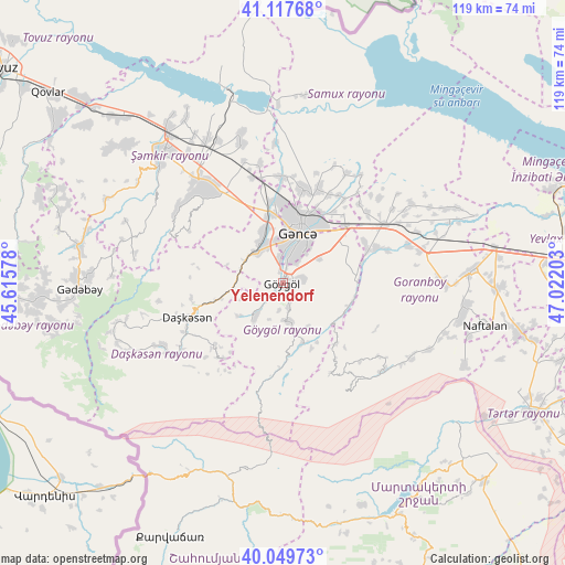
Yelenendorf GPS coordinates[2]
40° 35' 9.024" North, 46° 19' 8.04" East
| Map corner | latitude | longitude |
|---|---|---|
| Upper-left | 41.11768°, | 45.61578° |
| Center: | 40.58584°, | 46.3189° |
| Lower-right: | 40.04973°, | 47.02203° |
| Map W x H: | 118.7×118.7 km | = 73.8×73.8mi |
| max Lat: | 41.75259° ⇑33% North |
| Yelenendorf: | 40.58584° |
| min Lat: | ⇓67% South 38.45598° |
| min Long | Yelenendorf | max Long |
| 44.84846° | 46.3189° | 50.84003° |
| W 23.2%⇐ | ⇒76.8% E |
Elevation
Elevation of Yelenendorf is 686 m = 2251 ft, and this is 303 m = 994 ft above average elevation for this country.
| Max E: |
2211 m = 7254 ft | 24.9% |
| Yelenendorf | 686 m 2251 ft | |
| Avg. | 383 m = 1257 ft | |
Min E: |
-26 m = -85 ft | 75.1% |
See also: Azerbaijan elevation on elevation.city.
Geographical zone
Yelenendorf is located in North temperate zone (between Tropic of Cancer and the Arctic Circle). Distance of this Northern Tropic circle is 1906.8 km =1184.8 mi to South.| Distance of | km | miles | from Yelenendorf |
|---|---|---|---|
| North Pole | 5494.3 | 3414 | to North |
| Arctic Circle | 2888.5 | 1794.8 | to North |
| Tropic Cancer | 1906.8 | 1184.8 | to South |
| Equator | 4512.7 | 2804.1 | to South |


Nearby cities:
15 places around Yelenendorf: (largest is in red/bold)
• Alunitdağ
23.4 km =14.5 mi,  254°
254°
• Arıqdam
43.9 km =27.3 mi,  271°
271°
• Dolyar
39 km =24.2 mi,  322°
322°
• Ganja
11.3 km =7 mi,  18°
18°
• Goranboy
39.8 km =24.7 mi,  86°
86°
• Kyadabek
42.8 km =26.6 mi, 267°
• Naftalan
43.2 km =26.8 mi,  101°
101°
• Qarayeri
22.3 km =13.9 mi,  358°
358°
• Qasım İsmayılov
25.7 km =16 mi,  348°
348°
• Qazanbulaq
28.1 km =17.5 mi,  82°
82°
• Qırmızı Samux
39.7 km =24.7 mi,  7°
7°
• Samux
21.3 km =13.2 mi, 20°
• Shamkhor
37.1 km =23.1 mi, 316°
• Verkhniy Dashkesan
23.3 km =14.5 mi,  243°
243°
• Yukhary-Dashkesan
21.2 km =13.2 mi, 251°
Sources, notices
• [Note1] Compared only with cities in Azerbaijan existing in our database
• [Src1] Map data: © OpenStreetMap contributors (CC-BY-SA)
• [Src2] Other city data from geonames.org with taken over terms of usage.
• [Src3] Geographical zone / Annual Mean Temperature by Robert A. Rohde @ Wikipedia
