Magura geodata
Magura (Khulna) is a seat of a second-order administrative division; located in Bangladesh in Asia/Dhaka (GMT+6) time zone. In our database, there are 115 cities with bigger population. Compared to other cities in Bangladesh, 59.8% of cities are located further ↑North; 74.4% of cities are located further →East and 76.1% of cities have higher elevation than Magura. Note1
Administrative division(s):
- Level 1: Khulna
- Level 2: Magura
- Level 3: Magura Sadar Upazila
- Level 4: Paurashava


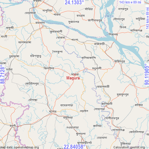
Magura GPS coordinates[2]
23° 29' 13.272" North, 89° 24' 57.312" East
| Map corner | latitude | longitude |
|---|---|---|
| Upper-left | 24.1303°, | 88.7128° |
| Center: | 23.48702°, | 89.41592° |
| Lower-right: | 22.84058°, | 90.11905° |
| Map W x H: | 143.4×143.4 km | = 89.1×89.1mi |
| max Lat: | 26.33338° ⇑59.8% North |
| Magura: | 23.48702° |
| min Lat: | ⇓40.2% South 20.85829° |
| min Long | Magura | max Long |
| 88.15638° | 89.41592° | 92.29773° |
| W 25.6%⇐ | ⇒74.4% E |
Elevation
Elevation of Magura is 11 m = 36 ft, and this is 6.9 m = 23 ft below average elevation for this country.
| Max E: |
79 m = 259 ft | 76.1% |
| Avg. | 17.9 m = 59 ft | |
| Magura | 11 m = 36 ft | |
Min E: |
2 m = 7 ft | 23.9% |
See also: Bangladesh elevation on elevation.city.
Geographical zone
Magura is located in North temperate zone (between Tropic of Cancer and the Arctic Circle). Distance of this Northern Tropic circle is 5.6 km =3.5 mi to South.| Distance of | km | miles | from Magura |
|---|---|---|---|
| North Pole | 7395.6 | 4595.4 | to North |
| Arctic Circle | 4789.7 | 2976.2 | to North |
| Tropic Cancer | 5.6 | 3.5 | to South |
| Equator | 2611.5 | 1622.7 | to South |


Nearby cities:
15 places around Magura: (largest is in red/bold)
• Bera
69.3 km =43.1 mi,  18°
18°
• Bherāmāra
73.7 km =45.8 mi,  324°
324°
• Bhātpāra Abhaynagar
52.6 km =32.7 mi,  177°
177°
• Dohār
75 km =46.6 mi,  80°
80°
• Farīdpur
45.3 km =28.1 mi,  72°
72°
• Jessore
40.9 km =25.4 mi,  210°
210°
• Jhingergācha
53.4 km =33.2 mi,  218°
218°
• Kesabpur
67.5 km =41.9 mi,  197°
197°
• Khulna
76.8 km =47.7 mi,  168°
168°
• Kushtia
55.2 km =34.3 mi,  326°
326°
• Kālia
54 km =33.6 mi,  156°
156°
• Kālīganj
29.6 km =18.4 mi,  253°
253°
• Narail
37.8 km =23.5 mi, 167°
• Nowlamary
48.2 km =30 mi,  295°
295°
• Pābna
60.6 km =37.7 mi,  342°
342°
Sources, notices
• [Note1] Compared only with cities in Bangladesh existing in our database
• [Src1] Map data: © OpenStreetMap contributors (CC-BY-SA)
• [Src2] Other city data from geonames.org with taken over terms of usage.
• [Src3] Geographical zone / Annual Mean Temperature by Robert A. Rohde @ Wikipedia
