Bhātpāra Abhaynagar geodata
Bhātpāra Abhaynagar (Khulna) is a populated place; located in Bangladesh in Asia/Dhaka (GMT+6) time zone. With population of 42,653 people, there are 72 cities with bigger population in this country. Compared to other cities in Bangladesh, 73.5% of cities are located further ↑North; 73.5% of cities are located further →East and 88.9% of cities have higher elevation than Bhātpāra Abhaynagar. Note1
Administrative division(s):
- Level 1: Khulna
- Level 2: Jessore
- Level 3: Abhaynagar Upazila
- Level 4: Baghutia


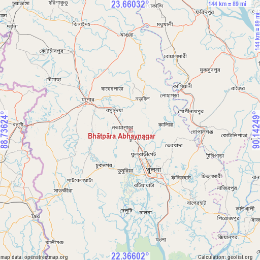
Bhātpāra Abhaynagar GPS coordinates[2]
23° 0' 52.992" North, 89° 26' 21.696" East
| Map corner | latitude | longitude |
|---|---|---|
| Upper-left | 23.66032°, | 88.73624° |
| Center: | 23.01472°, | 89.43936° |
| Lower-right: | 22.36602°, | 90.14249° |
| Map W x H: | 143.9×143.9 km | = 89.4×89.4mi |
| max Lat: | 26.33338° ⇑73.5% North |
| Bhātpāra Abhaynagar: | 23.01472° |
| min Lat: | ⇓26.5% South 20.85829° |
| min Long | Bhātpāra Abha | max Long |
| 88.15638° | 89.43936° | 92.29773° |
| W 26.5%⇐ | ⇒73.5% E |
Elevation
Elevation of Bhātpāra Abhaynagar is 9 m = 30 ft, and this is 8.9 m = 29 ft below average elevation for this country.
| Max E: |
79 m = 259 ft | 88.9% |
| Avg. | 17.9 m = 59 ft | |
| Bhātpāra Abhaynagar | 9 m = 30 ft | |
Min E: |
2 m = 7 ft | 11.1% |
See also: Bhātpāra Abhaynagar elevation on elevation.city.
Geographical zone
Bhātpāra Abhaynagar is located in North Torrid zone (between Equator and Tropic of Cancer). Distance of this Northern Tropic circle is 46.9 km =29.1 mi to North.| Distance of | km | miles | from Bhātpāra Abhaynagar |
|---|---|---|---|
| North Pole | 7448.1 | 4628 | to North |
| Arctic Circle | 4842.2 | 3008.8 | to North |
| Tropic Cancer | 46.9 | 29.1 | to North |
| Equator | 2559 | 1590.1 | to South |


Nearby cities:
15 places around Bhātpāra Abhaynagar: (largest is in red/bold)
• Bagerhat
53.7 km =33.4 mi,  137°
137°
• Farīdpur
77.5 km =48.2 mi,  31°
31°
• Jessore
28.8 km =17.9 mi,  306°
306°
• Jhingergācha
37.3 km =23.2 mi,  286°
286°
• Kesabpur
25.5 km =15.8 mi,  242°
242°
• Khulna
26.1 km =16.2 mi,  150°
150°
• Kālia
19.9 km =12.4 mi,  80°
80°
• Kālīganj
53.6 km =33.3 mi,  324°
324°
• Magura
52.6 km =32.7 mi,  357°
357°
• Morrelgonj
75.4 km =46.9 mi, 145°
• Narail
16.6 km =10.3 mi,  20°
20°
• Phultala
34 km =21.1 mi,  167°
167°
• Pirojpur
73.2 km =45.5 mi,  131°
131°
• Sātkhira
50.8 km =31.6 mi,  227°
227°
• Tungipāra
49.2 km =30.6 mi,  105°
105°
Sources, notices
• [Note1] Compared only with cities in Bangladesh existing in our database
• [Src1] Map data: © OpenStreetMap contributors (CC-BY-SA)
• [Src2] Other city data from geonames.org with taken over terms of usage.
• [Src3] Geographical zone / Annual Mean Temperature by Robert A. Rohde @ Wikipedia
