Nowlamary geodata
Nowlamary (Khulna) is a populated place; located in Bangladesh in Asia/Dhaka (GMT+6) time zone. With population of 3,500 people, there are 109 cities with bigger population in this country. Compared to other cities in Bangladesh, 55.6% of cities are located further ↑North; 88% of cities are located further →East and 57.3% of cities have lower elevation than Nowlamary. Note1


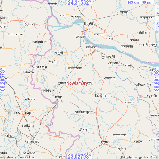
Nowlamary GPS coordinates[2]
23° 40' 24.456" North, 88° 59' 19.86" East
| Map corner | latitude | longitude |
|---|---|---|
| Upper-left | 24.31582°, | 88.28573° |
| Center: | 23.67346°, | 88.98885° |
| Lower-right: | 23.02793°, | 89.69198° |
| Map W x H: | 143.2×143.2 km | = 89×89mi |
| max Lat: | 26.33338° ⇑55.6% North |
| Nowlamary: | 23.67346° |
| min Lat: | ⇓44.4% South 20.85829° |
| min Long | Nowlamary | max Long |
| 88.15638° | 88.98885° | 92.29773° |
| W 12%⇐ | ⇒88% E |
Elevation
Elevation of Nowlamary is 16 m = 52 ft, and this is 1.9 m = 6 ft below average elevation for this country.
| Max E: |
79 m = 259 ft | 42.7% |
| Avg. | 17.9 m = 59 ft | |
| Nowlamary | 16 m = 52 ft | |
Min E: |
2 m = 7 ft | 57.3% |
See also: Bangladesh elevation on elevation.city.
Geographical zone
Nowlamary is located in North temperate zone (between Tropic of Cancer and the Arctic Circle). Distance of this Northern Tropic circle is 26.3 km =16.3 mi to South.| Distance of | km | miles | from Nowlamary |
|---|---|---|---|
| North Pole | 7374.8 | 4582.5 | to North |
| Arctic Circle | 4768.9 | 2963.3 | to North |
| Tropic Cancer | 26.3 | 16.3 | to South |
| Equator | 2632.2 | 1635.6 | to South |


Nearby cities:
15 places around Nowlamary: (largest is in red/bold)
• Bera
79.4 km =49.3 mi,  55°
55°
• Bherāmāra
39 km =24.2 mi,  0°
0°
• Bhātpāra Abhaynagar
86.5 km =53.7 mi,  147°
147°
• Ishurdi
51.2 km =31.8 mi,  8°
8°
• Jessore
60.5 km =37.6 mi,  157°
157°
• Jhingergācha
63.4 km =39.4 mi,  170°
170°
• Kushtia
28.8 km =17.9 mi,  27°
27°
• Kālīganj
33 km =20.5 mi, 152°
• Magura
48.2 km =30 mi,  115°
115°
• Narail
77.4 km =48.1 mi,  138°
138°
• Natore
82 km =51 mi,  359°
359°
• Puthia
78.5 km =48.8 mi,  348°
348°
• Pābna
44.8 km =27.8 mi, 34°
• Shāhzādpur
83.5 km =51.9 mi,  47°
47°
• Ujalpur
39.9 km =24.8 mi,  291°
291°
Sources, notices
• [Note1] Compared only with cities in Bangladesh existing in our database
• [Src1] Map data: © OpenStreetMap contributors (CC-BY-SA)
• [Src2] Other city data from geonames.org with taken over terms of usage.
• [Src3] Geographical zone / Annual Mean Temperature by Robert A. Rohde @ Wikipedia
