Narail geodata
Narail (Khulna) is a populated place; located in Bangladesh in Asia/Dhaka (GMT+6) time zone. With population of 55,112 people, there are 57 cities with bigger population in this country. Compared to other cities in Bangladesh, 67.5% of cities are located further ↑North; 71.8% of cities are located further →East and 76.1% of cities have higher elevation than Narail. Note1


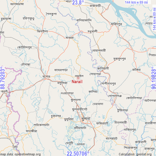
Narail GPS coordinates[2]
23° 9' 18.324" North, 89° 29' 42.54" East
| Map corner | latitude | longitude |
|---|---|---|
| Upper-left | 23.8°, | 88.79203° |
| Center: | 23.15509°, | 89.49515° |
| Lower-right: | 22.50706°, | 90.19828° |
| Map W x H: | 143.8×143.8 km | = 89.4×89.4mi |
| max Lat: | 26.33338° ⇑67.5% North |
| Narail: | 23.15509° |
| min Lat: | ⇓32.5% South 20.85829° |
| min Long | Narail | max Long |
| 88.15638° | 89.49515° | 92.29773° |
| W 28.2%⇐ | ⇒71.8% E |
Elevation
Elevation of Narail is 11 m = 36 ft, and this is 6.9 m = 23 ft below average elevation for this country.
| Max E: |
79 m = 259 ft | 76.1% |
| Avg. | 17.9 m = 59 ft | |
| Narail | 11 m = 36 ft | |
Min E: |
2 m = 7 ft | 23.9% |
See also: Narail elevation on elevation.city.
Geographical zone
Narail is located in North Torrid zone (between Equator and Tropic of Cancer). Distance of this Northern Tropic circle is 31.3 km =19.4 mi to North.| Distance of | km | miles | from Narail |
|---|---|---|---|
| North Pole | 7432.5 | 4618.3 | to North |
| Arctic Circle | 4826.6 | 2999.1 | to North |
| Tropic Cancer | 31.3 | 19.4 | to North |
| Equator | 2574.6 | 1599.8 | to South |


Nearby cities:
15 places around Narail: (largest is in red/bold)
• Bagerhat
63.2 km =39.3 mi,  151°
151°
• Bhātpāra Abhaynagar
16.6 km =10.3 mi,  200°
200°
• Char Bhadrāsan
76.7 km =47.7 mi,  77°
77°
• Farīdpur
61.3 km =38.1 mi,  35°
35°
• Jessore
28.8 km =17.9 mi,  273°
273°
• Jhingergācha
41.6 km =25.8 mi,  263°
263°
• Kesabpur
39.4 km =24.5 mi,  225°
225°
• Khulna
39 km =24.2 mi,  169°
169°
• Kālia
18.7 km =11.6 mi,  131°
131°
• Kālīganj
46.2 km =28.7 mi,  307°
307°
• Magura
37.8 km =23.5 mi,  347°
347°
• Mādārīpur
73 km =45.4 mi,  88°
88°
• Phultala
48.8 km =30.3 mi,  177°
177°
• Sātkhira
65.9 km =40.9 mi,  221°
221°
• Tungipāra
50.5 km =31.4 mi,  124°
124°
Sources, notices
• [Note1] Compared only with cities in Bangladesh existing in our database
• [Src1] Map data: © OpenStreetMap contributors (CC-BY-SA)
• [Src2] Other city data from geonames.org with taken over terms of usage.
• [Src3] Geographical zone / Annual Mean Temperature by Robert A. Rohde @ Wikipedia
