Kushtia geodata
Kushtia (Khulna) is a populated place; located in Bangladesh in Asia/Dhaka (GMT+6) time zone. With population of 135,724 people, there are 28 cities with bigger population in this country. Compared to other cities in Bangladesh, 56.4% of cities are located further ↓South; 82.1% of cities are located further →East and 62.4% of cities have lower elevation than Kushtia. Note1
Administrative division(s):
- Level 1: Khulna
- Level 2: Kushtia
- Level 3: Kushtia Sadar Upazila
- Level 4: Paurashava


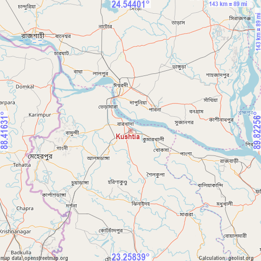
Kushtia GPS coordinates[2]
23° 54' 10.08" North, 89° 7' 9.948" East
| Map corner | latitude | longitude |
|---|---|---|
| Upper-left | 24.54401°, | 88.41631° |
| Center: | 23.9028°, | 89.11943° |
| Lower-right: | 23.25839°, | 89.82256° |
| Map W x H: | 142.9×142.9 km | = 88.8×88.8mi |
| max Lat: | 26.33338° ⇑43.6% North |
| Kushtia: | 23.9028° |
| min Lat: | ⇓56.4% South 20.85829° |
| min Long | Kushtia | max Long |
| 88.15638° | 89.11943° | 92.29773° |
| W 17.9%⇐ | ⇒82.1% E |
Elevation
Elevation of Kushtia is 17 m = 56 ft, and this is 0.9 m = 3 ft below average elevation for this country.
| Max E: |
79 m = 259 ft | 37.6% |
| Avg. | 17.9 m = 59 ft | |
| Kushtia | 17 m = 56 ft | |
Min E: |
2 m = 7 ft | 62.4% |
See also: Kushtia elevation on elevation.city.
Geographical zone
Kushtia is located in North temperate zone (between Tropic of Cancer and the Arctic Circle). Distance of this Northern Tropic circle is 51.8 km =32.2 mi to South.| Distance of | km | miles | from Kushtia |
|---|---|---|---|
| North Pole | 7349.3 | 4566.6 | to North |
| Arctic Circle | 4743.4 | 2947.4 | to North |
| Tropic Cancer | 51.8 | 32.2 | to South |
| Equator | 2657.7 | 1651.4 | to South |


Nearby cities:
15 places around Kushtia: (largest is in red/bold)
• Bera
55.7 km =34.6 mi,  69°
69°
• Bherāmāra
18.7 km =11.6 mi,  316°
316°
• Farīdpur
80.5 km =50 mi,  114°
114°
• Ishurdi
25.7 km =16 mi,  347°
347°
• Jessore
82.1 km =51 mi,  173°
173°
• Kālīganj
54.9 km =34.1 mi,  178°
178°
• Magura
55.2 km =34.3 mi,  146°
146°
• Natore
58.1 km =36.1 mi, 346°
• Nowlamary
28.8 km =17.9 mi,  207°
207°
• Nāgarpur
78.9 km =49 mi,  77°
77°
• Puthia
59 km =36.7 mi,  330°
330°
• Pābna
16.6 km =10.3 mi,  46°
46°
• Rājshāhi
74.2 km =46.1 mi,  314°
314°
• Shāhzādpur
57.4 km =35.7 mi,  57°
57°
• Ujalpur
51.5 km =32 mi,  257°
257°
Sources, notices
• [Note1] Compared only with cities in Bangladesh existing in our database
• [Src1] Map data: © OpenStreetMap contributors (CC-BY-SA)
• [Src2] Other city data from geonames.org with taken over terms of usage.
• [Src3] Geographical zone / Annual Mean Temperature by Robert A. Rohde @ Wikipedia
