Bherāmāra geodata
Bherāmāra (Khulna) is a populated place; located in Bangladesh in Asia/Dhaka (GMT+6) time zone. With population of 38,159 people, there are 85 cities with bigger population in this country. Compared to other cities in Bangladesh, 59% of cities are located further ↓South; 87.2% of cities are located further →East and 66.7% of cities have lower elevation than Bherāmāra. Note1


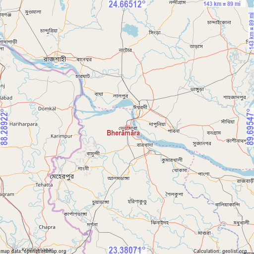
Bherāmāra GPS coordinates[2]
24° 1' 28.272" North, 88° 59' 32.424" East
| Map corner | latitude | longitude |
|---|---|---|
| Upper-left | 24.66512°, | 88.28922° |
| Center: | 24.02452°, | 88.99234° |
| Lower-right: | 23.38071°, | 89.69547° |
| Map W x H: | 142.8×142.8 km | = 88.7×88.7mi |
| max Lat: | 26.33338° ⇑41% North |
| Bherāmāra: | 24.02452° |
| min Lat: | ⇓59% South 20.85829° |
| min Long | Bherāmāra | max Long |
| 88.15638° | 88.99234° | 92.29773° |
| W 12.8%⇐ | ⇒87.2% E |
Elevation
Elevation of Bherāmāra is 19 m = 62 ft, and this is 1.1 m = 4 ft above average elevation for this country.
| Max E: |
79 m = 259 ft | 33.3% |
| Bherāmāra | 19 m 62 ft | |
| Avg. | 17.9 m = 59 ft | |
Min E: |
2 m = 7 ft | 66.7% |
See also: Bangladesh elevation on elevation.city.
Geographical zone
Bherāmāra is located in North temperate zone (between Tropic of Cancer and the Arctic Circle). Distance of this Northern Tropic circle is 65.4 km =40.6 mi to South.| Distance of | km | miles | from Bherāmāra |
|---|---|---|---|
| North Pole | 7335.8 | 4558.3 | to North |
| Arctic Circle | 4729.9 | 2939 | to North |
| Tropic Cancer | 65.4 | 40.6 | to South |
| Equator | 2671.3 | 1659.9 | to South |


Nearby cities:
15 places around Bherāmāra: (largest is in red/bold)
• Bera
65.3 km =40.6 mi,  84°
84°
• Ishurdi
13.8 km =8.6 mi,  32°
32°
• Kushtia
18.7 km =11.6 mi,  136°
136°
• Kālīganj
70 km =43.5 mi,  167°
167°
• Magura
73.7 km =45.8 mi, 144°
• Natore
43 km =26.7 mi,  359°
359°
• Nowlamary
39 km =24.2 mi,  180°
180°
• Nāgarpur
89.9 km =55.9 mi,  87°
87°
• Puthia
41.1 km =25.5 mi,  337°
337°
• Pābna
25 km =15.5 mi, 94°
• Pār Naogaon
86.8 km =53.9 mi, 357°
• Rājshāhi
55.5 km =34.5 mi,  314°
314°
• Shāhzādpur
63.8 km =39.6 mi,  74°
74°
• Sirajganj
87.1 km =54.1 mi,  56°
56°
• Ujalpur
44.6 km =27.7 mi,  236°
236°
Sources, notices
• [Note1] Compared only with cities in Bangladesh existing in our database
• [Src1] Map data: © OpenStreetMap contributors (CC-BY-SA)
• [Src2] Other city data from geonames.org with taken over terms of usage.
• [Src3] Geographical zone / Annual Mean Temperature by Robert A. Rohde @ Wikipedia
