Rājshāhi geodata
Rājshāhi (Rajshahi Division) is a seat of a first-order administrative division; located in Bangladesh in Asia/Dhaka (GMT+6) time zone. With population of 700,133 people, there are 3 cities with bigger population in this country. Compared to other cities in Bangladesh, 68.4% of cities are located further ↓South; 95.7% of cities are located further →East and 76.9% of cities have lower elevation than Rājshāhi. Note1
Administrative division(s):
- Level 1: Rajshahi Division
- Level 2: Rajshahi
- Level 3: Boalia Upazila
- Level 4: Ward - 13


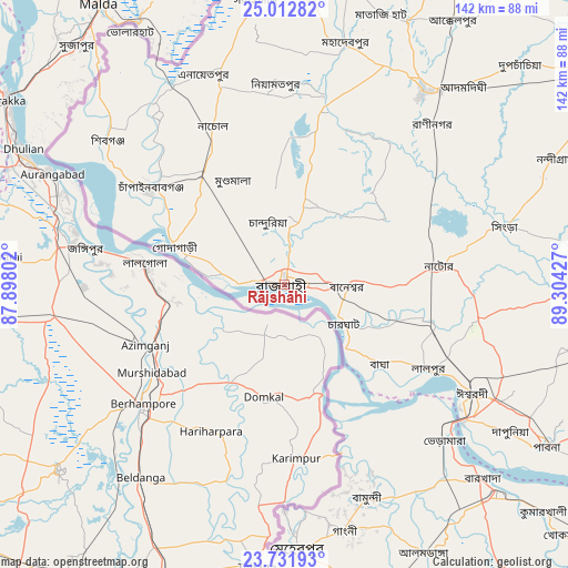
Rājshāhi GPS coordinates[2]
24° 22' 26.4" North, 88° 36' 4.104" East
| Map corner | latitude | longitude |
|---|---|---|
| Upper-left | 25.01282°, | 87.89802° |
| Center: | 24.374°, | 88.60114° |
| Lower-right: | 23.73193°, | 89.30427° |
| Map W x H: | 142.4×142.4 km | = 88.5×88.5mi |
| max Lat: | 26.33338° ⇑31.6% North |
| Rājshāhi: | 24.374° |
| min Lat: | ⇓68.4% South 20.85829° |
| min Long | Rājshāhi | max Long |
| 88.15638° | 88.60114° | 92.29773° |
| W 4.3%⇐ | ⇒95.7% E |
Elevation
Elevation of Rājshāhi is 23 m = 75 ft, and this is 5.1 m = 17 ft above average elevation for this country.
| Max E: |
79 m = 259 ft | 23.1% |
| Rājshāhi | 23 m 75 ft | |
| Avg. | 17.9 m = 59 ft | |
Min E: |
2 m = 7 ft | 76.9% |
See also: Rājshāhi elevation on elevation.city.
Geographical zone
Rājshāhi is located in North temperate zone (between Tropic of Cancer and the Arctic Circle). Distance of this Northern Tropic circle is 104.2 km =64.7 mi to South.| Distance of | km | miles | from Rājshāhi |
|---|---|---|---|
| North Pole | 7296.9 | 4534.1 | to North |
| Arctic Circle | 4691 | 2914.9 | to North |
| Tropic Cancer | 104.2 | 64.7 | to South |
| Equator | 2710.1 | 1684 | to South |


Nearby cities:
15 places around Rājshāhi: (largest is in red/bold)
• Bherāmāra
55.5 km =34.5 mi,  134°
134°
• Bogra
94.2 km =58.5 mi,  55°
55°
• Ishurdi
54.4 km =33.8 mi,  120°
120°
• Joypur Hāt
91.6 km =56.9 mi,  28°
28°
• Kushtia
74.2 km =46.1 mi, 134°
• Mahasthangarh
99.4 km =61.8 mi,  48°
48°
• Natore
39.3 km =24.4 mi,  83°
83°
• Nawābganj
40.9 km =25.4 mi,  306°
306°
• Nowlamary
87.3 km =54.2 mi,  153°
153°
• Paharpur
81.9 km =50.9 mi, 27°
• Puthia
23.6 km =14.7 mi,  92°
92°
• Pābna
76.4 km =47.5 mi, 122°
• Pār Naogaon
59.4 km =36.9 mi,  36°
36°
• Shibganj
56.7 km =35.2 mi, 307°
• Ujalpur
63.2 km =39.3 mi,  177°
177°
Sources, notices
• [Note1] Compared only with cities in Bangladesh existing in our database
• [Src1] Map data: © OpenStreetMap contributors (CC-BY-SA)
• [Src2] Other city data from geonames.org with taken over terms of usage.
• [Src3] Geographical zone / Annual Mean Temperature by Robert A. Rohde @ Wikipedia
