Puthia geodata
Puthia (Rajshahi Division) is a populated place; located in Bangladesh in Asia/Dhaka (GMT+6) time zone. With population of 159,406 people, there are 26 cities with bigger population in this country. Compared to other cities in Bangladesh, 67.5% of cities are located further ↓South; 93.2% of cities are located further →East and 71.8% of cities have lower elevation than Puthia. Note1
Administrative division(s):
- Level 1: Rajshahi Division
- Level 2: Rajshahi
- Level 3: Puthia Upazila
- Level 4: Puthia


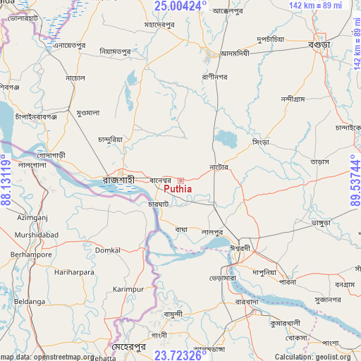
Puthia GPS coordinates[2]
24° 21' 55.332" North, 88° 50' 3.516" East
| Map corner | latitude | longitude |
|---|---|---|
| Upper-left | 25.00424°, | 88.13119° |
| Center: | 24.36537°, | 88.83431° |
| Lower-right: | 23.72326°, | 89.53744° |
| Map W x H: | 142.4×142.4 km | = 88.5×88.5mi |
| max Lat: | 26.33338° ⇑32.5% North |
| Puthia: | 24.36537° |
| min Lat: | ⇓67.5% South 20.85829° |
| min Long | Puthia | max Long |
| 88.15638° | 88.83431° | 92.29773° |
| W 6.8%⇐ | ⇒93.2% E |
Elevation
Elevation of Puthia is 20 m = 66 ft, and this is 2.1 m = 7 ft above average elevation for this country.
| Max E: |
79 m = 259 ft | 28.2% |
| Puthia | 20 m 66 ft | |
| Avg. | 17.9 m = 59 ft | |
Min E: |
2 m = 7 ft | 71.8% |
See also: Puthia elevation on elevation.city.
Geographical zone
Puthia is located in North temperate zone (between Tropic of Cancer and the Arctic Circle). Distance of this Northern Tropic circle is 103.3 km =64.2 mi to South.| Distance of | km | miles | from Puthia |
|---|---|---|---|
| North Pole | 7297.9 | 4534.7 | to North |
| Arctic Circle | 4692 | 2915.5 | to North |
| Tropic Cancer | 103.3 | 64.2 | to South |
| Equator | 2709.2 | 1683.4 | to South |


Nearby cities:
15 places around Puthia: (largest is in red/bold)
• Bherāmāra
41.1 km =25.5 mi,  157°
157°
• Bogra
76.5 km =47.5 mi,  45°
45°
• Ishurdi
35.3 km =21.9 mi,  138°
138°
• Kushtia
59 km =36.7 mi,  150°
150°
• Mahasthangarh
83.8 km =52.1 mi,  37°
37°
• Natore
16.3 km =10.1 mi,  71°
71°
• Nawābganj
61.9 km =38.5 mi,  293°
293°
• Nowlamary
78.5 km =48.8 mi,  168°
168°
• Paharpur
74.9 km =46.5 mi,  11°
11°
• Pābna
57.1 km =35.5 mi,  134°
134°
• Pār Naogaon
50.1 km =31.1 mi, 13°
• Rājshāhi
23.6 km =14.7 mi,  272°
272°
• Shibganj
77.2 km =48 mi,  297°
297°
• Shāhzādpur
80.3 km =49.9 mi,  105°
105°
• Ujalpur
65.8 km =40.9 mi,  198°
198°
Sources, notices
• [Note1] Compared only with cities in Bangladesh existing in our database
• [Src1] Map data: © OpenStreetMap contributors (CC-BY-SA)
• [Src2] Other city data from geonames.org with taken over terms of usage.
• [Src3] Geographical zone / Annual Mean Temperature by Robert A. Rohde @ Wikipedia
