Natore geodata
Natore (Rajshahi Division) is a populated place; located in Bangladesh in Asia/Dhaka (GMT+6) time zone. With population of 369,138 people, there are 6 cities with bigger population in this country. Compared to other cities in Bangladesh, 70.1% of cities are located further ↓South; 88.9% of cities are located further →East and 73.5% of cities have lower elevation than Natore. Note1
Administrative division(s):
- Level 1: Rajshahi Division
- Level 2: Natore
- Level 3: Natore S.
- Level 4: Paurashava


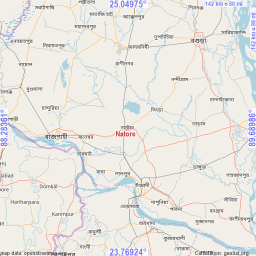
Natore GPS coordinates[2]
24° 24' 40.032" North, 88° 59' 12.228" East
| Map corner | latitude | longitude |
|---|---|---|
| Upper-left | 25.04975°, | 88.28361° |
| Center: | 24.41112°, | 88.98673° |
| Lower-right: | 23.76924°, | 89.68986° |
| Map W x H: | 142.4×142.4 km | = 88.5×88.5mi |
| max Lat: | 26.33338° ⇑29.9% North |
| Natore: | 24.41112° |
| min Lat: | ⇓70.1% South 20.85829° |
| min Long | Natore | max Long |
| 88.15638° | 88.98673° | 92.29773° |
| W 11.1%⇐ | ⇒88.9% E |
Elevation
Elevation of Natore is 22 m = 72 ft, and this is 4.1 m = 13 ft above average elevation for this country.
| Max E: |
79 m = 259 ft | 26.5% |
| Natore | 22 m 72 ft | |
| Avg. | 17.9 m = 59 ft | |
Min E: |
2 m = 7 ft | 73.5% |
See also: Natore elevation on elevation.city.
Geographical zone
Natore is located in North temperate zone (between Tropic of Cancer and the Arctic Circle). Distance of this Northern Tropic circle is 108.3 km =67.3 mi to South.| Distance of | km | miles | from Natore |
|---|---|---|---|
| North Pole | 7292.8 | 4531.5 | to North |
| Arctic Circle | 4686.9 | 2912.3 | to North |
| Tropic Cancer | 108.3 | 67.3 | to South |
| Equator | 2714.3 | 1686.6 | to South |


Nearby cities:
15 places around Natore: (largest is in red/bold)
• Bera
75.2 km =46.7 mi,  119°
119°
• Bherāmāra
43 km =26.7 mi,  179°
179°
• Bogra
62.5 km =38.8 mi,  38°
38°
• Ishurdi
32.4 km =20.1 mi,  165°
165°
• Kushtia
58.1 km =36.1 mi, 166°
• Mahasthangarh
70.9 km =44.1 mi,  30°
30°
• Nawābganj
74.8 km =46.5 mi,  285°
285°
• Paharpur
68.5 km =42.6 mi,  359°
359°
• Puthia
16.3 km =10.1 mi,  251°
251°
• Pābna
51.7 km =32.1 mi,  150°
150°
• Pār Naogaon
43.9 km =27.3 mi,  354°
354°
• Rājshāhi
39.3 km =24.4 mi,  263°
263°
• Shibganj
73.9 km =45.9 mi, 27°
• Shāhzādpur
67.3 km =41.8 mi,  112°
112°
• Sirajganj
73.2 km =45.5 mi,  85°
85°
Sources, notices
• [Note1] Compared only with cities in Bangladesh existing in our database
• [Src1] Map data: © OpenStreetMap contributors (CC-BY-SA)
• [Src2] Other city data from geonames.org with taken over terms of usage.
• [Src3] Geographical zone / Annual Mean Temperature by Robert A. Rohde @ Wikipedia
