Ishurdi geodata
Ishurdi (Rajshahi Division) is a populated place; located in Bangladesh in Asia/Dhaka (GMT+6) time zone. With population of 81,995 people, there are 44 cities with bigger population in this country. Compared to other cities in Bangladesh, 63.2% of cities are located further ↓South; 84.6% of cities are located further →East and 66.7% of cities have lower elevation than Ishurdi. Note1
Administrative division(s):
- Level 1: Rajshahi Division
- Level 2: Pabna
- Level 3: Ishwardi Upazila
- Level 4: Paurashava


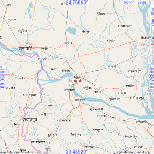
Ishurdi GPS coordinates[2]
24° 7' 42.888" North, 89° 3' 56.628" East
| Map corner | latitude | longitude |
|---|---|---|
| Upper-left | 24.76865°, | 88.36261° |
| Center: | 24.12858°, | 89.06573° |
| Lower-right: | 23.48529°, | 89.76886° |
| Map W x H: | 142.7×142.7 km | = 88.7×88.7mi |
| max Lat: | 26.33338° ⇑36.8% North |
| Ishurdi: | 24.12858° |
| min Lat: | ⇓63.2% South 20.85829° |
| min Long | Ishurdi | max Long |
| 88.15638° | 89.06573° | 92.29773° |
| W 15.4%⇐ | ⇒84.6% E |
Elevation
Elevation of Ishurdi is 19 m = 62 ft, and this is 1.1 m = 4 ft above average elevation for this country.
| Max E: |
79 m = 259 ft | 33.3% |
| Ishurdi | 19 m 62 ft | |
| Avg. | 17.9 m = 59 ft | |
Min E: |
2 m = 7 ft | 66.7% |
See also: Ishurdi elevation on elevation.city.
Geographical zone
Ishurdi is located in North temperate zone (between Tropic of Cancer and the Arctic Circle). Distance of this Northern Tropic circle is 76.9 km =47.8 mi to South.| Distance of | km | miles | from Ishurdi |
|---|---|---|---|
| North Pole | 7324.2 | 4551 | to North |
| Arctic Circle | 4718.3 | 2931.8 | to North |
| Tropic Cancer | 76.9 | 47.8 | to South |
| Equator | 2682.8 | 1667 | to South |


Nearby cities:
15 places around Ishurdi: (largest is in red/bold)
• Bera
57.8 km =35.9 mi,  95°
95°
• Bherāmāra
13.8 km =8.6 mi,  212°
212°
• Kushtia
25.7 km =16 mi,  167°
167°
• Kālīganj
80.3 km =49.9 mi, 174°
• Magura
79.7 km =49.5 mi,  153°
153°
• Natore
32.4 km =20.1 mi,  345°
345°
• Nowlamary
51.2 km =31.8 mi,  188°
188°
• Nāgarpur
82.7 km =51.4 mi, 95°
• Puthia
35.3 km =21.9 mi,  318°
318°
• Pābna
22.1 km =13.7 mi,  127°
127°
• Pār Naogaon
76 km =47.2 mi, 351°
• Rājshāhi
54.4 km =33.8 mi,  300°
300°
• Shāhzādpur
54.3 km =33.7 mi,  84°
84°
• Sirajganj
74.7 km =46.4 mi,  60°
60°
• Ujalpur
57.4 km =35.7 mi,  231°
231°
Sources, notices
• [Note1] Compared only with cities in Bangladesh existing in our database
• [Src1] Map data: © OpenStreetMap contributors (CC-BY-SA)
• [Src2] Other city data from geonames.org with taken over terms of usage.
• [Src3] Geographical zone / Annual Mean Temperature by Robert A. Rohde @ Wikipedia
