Muktāgācha geodata
Muktāgācha (Mymensingh Division) is a populated place; located in Bangladesh in Asia/Dhaka (GMT+6) time zone. With population of 24,684 people, there are 103 cities with bigger population in this country. Compared to other cities in Bangladesh, 78.6% of cities are located further ↓South; 59% of cities are located further ←West and 73.5% of cities have lower elevation than Muktāgācha. Note1
Administrative division(s):
- Level 1: Mymensingh Division
- Level 2: Mymensingh
- Level 3: Muktagacha Upazila
- Level 4: Paurashava


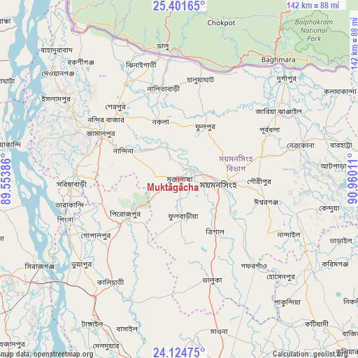
Muktāgācha GPS coordinates[2]
24° 45' 53.424" North, 90° 15' 25.128" East
| Map corner | latitude | longitude |
|---|---|---|
| Upper-left | 25.40165°, | 89.55386° |
| Center: | 24.76484°, | 90.25698° |
| Lower-right: | 24.12475°, | 90.96011° |
| Map W x H: | 142×142 km | = 88.2×88.2mi |
| max Lat: | 26.33338° ⇑21.4% North |
| Muktāgācha: | 24.76484° |
| min Lat: | ⇓78.6% South 20.85829° |
| min Long | Muktāgācha | max Long |
| 88.15638° | 90.25698° | 92.29773° |
| W 59%⇐ | ⇒41% E |
Elevation
Elevation of Muktāgācha is 22 m = 72 ft, and this is 4.1 m = 13 ft above average elevation for this country.
| Max E: |
79 m = 259 ft | 26.5% |
| Muktāgācha | 22 m 72 ft | |
| Avg. | 17.9 m = 59 ft | |
Min E: |
2 m = 7 ft | 73.5% |
See also: Bangladesh elevation on elevation.city.
Geographical zone
Muktāgācha is located in North temperate zone (between Tropic of Cancer and the Arctic Circle). Distance of this Northern Tropic circle is 147.7 km =91.8 mi to South.| Distance of | km | miles | from Muktāgācha |
|---|---|---|---|
| North Pole | 7253.5 | 4507.1 | to North |
| Arctic Circle | 4647.6 | 2887.9 | to North |
| Tropic Cancer | 147.7 | 91.8 | to South |
| Equator | 2753.6 | 1711 | to South |


Nearby cities:
15 places around Muktāgācha: (largest is in red/bold)
• Bogra
89.9 km =55.9 mi,  276°
276°
• Bājitpur
92.9 km =57.7 mi,  131°
131°
• Gafargaon
47.9 km =29.8 mi,  140°
140°
• Jamālpur
35.6 km =22.1 mi,  298°
298°
• Kishorganj
64.3 km =40 mi,  124°
124°
• Mirzāpur
75.3 km =46.8 mi,  192°
192°
• Mymensingh
15.1 km =9.4 mi,  93°
93°
• Netrakona
49.4 km =30.7 mi,  74°
74°
• Nāgarpur
87.5 km =54.4 mi,  206°
206°
• Purbadhala
39.8 km =24.7 mi,  60°
60°
• Sakhipur
50.3 km =31.3 mi, 190°
• Sarishābāri
43 km =26.7 mi,  267°
267°
• Sherpur
37.2 km =23.1 mi,  319°
319°
• Sirajganj
65.2 km =40.5 mi,  238°
238°
• Tāngāil
66.8 km =41.5 mi, 211°
Sources, notices
• [Note1] Compared only with cities in Bangladesh existing in our database
• [Src1] Map data: © OpenStreetMap contributors (CC-BY-SA)
• [Src2] Other city data from geonames.org with taken over terms of usage.
• [Src3] Geographical zone / Annual Mean Temperature by Robert A. Rohde @ Wikipedia
