Mymensingh geodata
Mymensingh (Mymensingh Division) is a seat of a first-order administrative division; located in Bangladesh in Asia/Dhaka (GMT+6) time zone. With population of 225,126 people, there are 15 cities with bigger population in this country. Compared to other cities in Bangladesh, 77.8% of cities are located further ↓South; 64.1% of cities are located further ←West and 66.7% of cities have lower elevation than Mymensingh. Note1
Administrative division(s):
- Level 1: Mymensingh Division
- Level 2: Mymensingh
- Level 3: Mymensingh S.
- Level 4: Paurashava


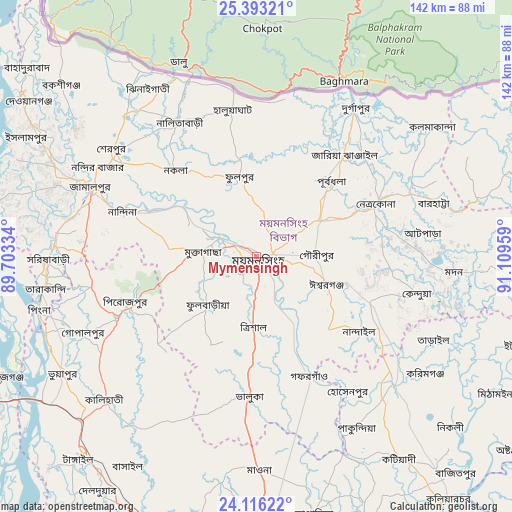
Mymensingh GPS coordinates[2]
24° 45' 22.896" North, 90° 24' 23.256" East
| Map corner | latitude | longitude |
|---|---|---|
| Upper-left | 25.39321°, | 89.70334° |
| Center: | 24.75636°, | 90.40646° |
| Lower-right: | 24.11622°, | 91.10959° |
| Map W x H: | 142×142 km | = 88.2×88.2mi |
| max Lat: | 26.33338° ⇑22.2% North |
| Mymensingh: | 24.75636° |
| min Lat: | ⇓77.8% South 20.85829° |
| min Long | Mymensingh | max Long |
| 88.15638° | 90.40646° | 92.29773° |
| W 64.1%⇐ | ⇒35.9% E |
Elevation
Elevation of Mymensingh is 19 m = 62 ft, and this is 1.1 m = 4 ft above average elevation for this country.
| Max E: |
79 m = 259 ft | 33.3% |
| Mymensingh | 19 m 62 ft | |
| Avg. | 17.9 m = 59 ft | |
Min E: |
2 m = 7 ft | 66.7% |
See also: Mymensingh elevation on elevation.city.
Geographical zone
Mymensingh is located in North temperate zone (between Tropic of Cancer and the Arctic Circle). Distance of this Northern Tropic circle is 146.7 km =91.2 mi to South.| Distance of | km | miles | from Mymensingh |
|---|---|---|---|
| North Pole | 7254.4 | 4507.7 | to North |
| Arctic Circle | 4648.5 | 2888.4 | to North |
| Tropic Cancer | 146.7 | 91.2 | to South |
| Equator | 2752.6 | 1710.4 | to South |


Nearby cities:
15 places around Mymensingh: (largest is in red/bold)
• Bājitpur
81.4 km =50.6 mi,  137°
137°
• Gafargaon
39.2 km =24.4 mi,  156°
156°
• Jamālpur
49.7 km =30.9 mi,  291°
291°
• Kishorganj
51.9 km =32.2 mi,  132°
132°
• Mirzāpur
79.1 km =49.2 mi,  203°
203°
• Muktāgācha
15.1 km =9.4 mi,  273°
273°
• Netrakona
35.5 km =22.1 mi,  66°
66°
• Nāgarpur
94.4 km =58.7 mi,  214°
214°
• Purbadhala
28.3 km =17.6 mi,  43°
43°
• Sakhipur
54.1 km =33.6 mi, 206°
• Sarishābāri
58.1 km =36.1 mi, 269°
• Sherpur
48.9 km =30.4 mi,  306°
306°
• Sirajganj
78 km =48.5 mi,  244°
244°
• Tungi
96.2 km =59.8 mi,  180°
180°
• Tāngāil
75 km =46.6 mi,  221°
221°
Sources, notices
• [Note1] Compared only with cities in Bangladesh existing in our database
• [Src1] Map data: © OpenStreetMap contributors (CC-BY-SA)
• [Src2] Other city data from geonames.org with taken over terms of usage.
• [Src3] Geographical zone / Annual Mean Temperature by Robert A. Rohde @ Wikipedia
