Gaurnadi geodata
Gaurnadi (Barisāl) is a populated place; located in Bangladesh in Asia/Dhaka (GMT+6) time zone. With population of 40,519 people, there are 78 cities with bigger population in this country. Compared to other cities in Bangladesh, 75.2% of cities are located further ↑North; 57.3% of cities are located further ←West and 70.1% of cities have higher elevation than Gaurnadi. Note1
Administrative division(s):
- Level 1: Barisāl
- Level 2: Barisal
- Level 3: Gaurnadi Upazila
- Level 4: Chandshi


Gaurnadi GPS coordinates[2]
22° 58' 25.392" North, 90° 13' 25.536" East
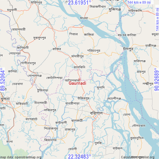
| Map corner | latitude | longitude |
|---|---|---|
| Upper-left | 23.61951°, | 89.52064° |
| Center: | 22.97372°, | 90.22376° |
| Lower-right: | 22.32483°, | 90.92689° |
| Map W x H: | 144×144 km | = 89.5×89.5mi |
| max Lat: | 26.33338° ⇑75.2% North |
| Gaurnadi: | 22.97372° |
| min Lat: | ⇓24.8% South 20.85829° |
| min Long | Gaurnadi | max Long |
| 88.15638° | 90.22376° | 92.29773° |
| W 57.3%⇐ | ⇒42.7% E |
Elevation
Elevation of Gaurnadi is 12 m = 39 ft, and this is 5.9 m = 19 ft below average elevation for this country.
| Max E: |
79 m = 259 ft | 70.1% |
| Avg. | 17.9 m = 59 ft | |
| Gaurnadi | 12 m = 39 ft | |
Min E: |
2 m = 7 ft | 29.9% |
See also: Gaurnadi elevation on elevation.city.
Geographical zone
Gaurnadi is located in North Torrid zone (between Equator and Tropic of Cancer). Distance of this Northern Tropic circle is 51.5 km =32 mi to North.| Distance of | km | miles | from Gaurnadi |
|---|---|---|---|
| North Pole | 7452.6 | 4630.8 | to North |
| Arctic Circle | 4846.7 | 3011.6 | to North |
| Tropic Cancer | 51.5 | 32 | to North |
| Equator | 2554.4 | 1587.2 | to South |


Nearby cities:
15 places around Gaurnadi: (largest is in red/bold)
• Bagerhat
56.6 km =35.2 mi,  231°
231°
• Barisāl
33.4 km =20.8 mi,  153°
153°
• Bhola
53.5 km =33.2 mi,  126°
126°
• Bhāndāria
56.4 km =35 mi,  197°
197°
• Char Bhadrāsan
37.3 km =23.2 mi,  0°
0°
• Kālia
61.2 km =38 mi,  277°
277°
• Lakshmīpur
62.2 km =38.6 mi,  93°
93°
• Mehendiganj
35.5 km =22.1 mi,  118°
118°
• Mādārīpur
22 km =13.7 mi,  356°
356°
• Nālchiti
37.8 km =23.5 mi,  172°
172°
• Pirojpur
50.7 km =31.5 mi,  210°
210°
• Pālang
30.1 km =18.7 mi,  25°
25°
• Rāipur
56.2 km =34.9 mi,  82°
82°
• Rāmganj
65.6 km =40.8 mi, 77°
• Tungipāra
33.8 km =21 mi,  255°
255°
Sources, notices
• [Note1] Compared only with cities in Bangladesh existing in our database
• [Src1] Map data: © OpenStreetMap contributors (CC-BY-SA)
• [Src2] Other city data from geonames.org with taken over terms of usage.
• [Src3] Geographical zone / Annual Mean Temperature by Robert A. Rohde @ Wikipedia
