Mādārīpur geodata
Mādārīpur (Dhaka) is a populated place; located in Bangladesh in Asia/Dhaka (GMT+6) time zone. With population of 84,789 people, there are 41 cities with bigger population in this country. Compared to other cities in Bangladesh, 65.8% of cities are located further ↑North; 56.4% of cities are located further ←West and 81.2% of cities have higher elevation than Mādārīpur. Note1
Administrative division(s):
- Level 1: Dhaka
- Level 2: Madaripur
- Level 3: Madaripur S.
- Level 4: Paurashava


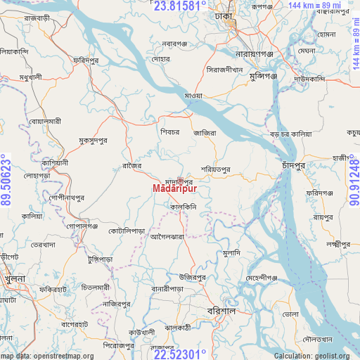
Mādārīpur GPS coordinates[2]
23° 10' 15.492" North, 90° 12' 33.66" East
| Map corner | latitude | longitude |
|---|---|---|
| Upper-left | 23.81581°, | 89.50623° |
| Center: | 23.17097°, | 90.20935° |
| Lower-right: | 22.52301°, | 90.91248° |
| Map W x H: | 143.7×143.7 km | = 89.3×89.3mi |
| max Lat: | 26.33338° ⇑65.8% North |
| Mādārīpur: | 23.17097° |
| min Lat: | ⇓34.2% South 20.85829° |
| min Long | Mādārīpur | max Long |
| 88.15638° | 90.20935° | 92.29773° |
| W 56.4%⇐ | ⇒43.6% E |
Elevation
Elevation of Mādārīpur is 10 m = 33 ft, and this is 7.9 m = 26 ft below average elevation for this country.
| Max E: |
79 m = 259 ft | 81.2% |
| Avg. | 17.9 m = 59 ft | |
| Mādārīpur | 10 m = 33 ft | |
Min E: |
2 m = 7 ft | 18.8% |
See also: Mādārīpur elevation on elevation.city.
Geographical zone
Mādārīpur is located in North Torrid zone (between Equator and Tropic of Cancer). Distance of this Northern Tropic circle is 29.5 km =18.3 mi to North.| Distance of | km | miles | from Mādārīpur |
|---|---|---|---|
| North Pole | 7430.7 | 4617.2 | to North |
| Arctic Circle | 4824.8 | 2998 | to North |
| Tropic Cancer | 29.5 | 18.3 | to North |
| Equator | 2576.4 | 1600.9 | to South |


Nearby cities:
15 places around Mādārīpur: (largest is in red/bold)
• Azimpur
64.7 km =40.2 mi,  16°
16°
• Barisāl
54.4 km =33.8 mi,  162°
162°
• Char Bhadrāsan
15.5 km =9.6 mi,  6°
6°
• Dhaka
63.3 km =39.3 mi, 18°
• Dohār
47.4 km =29.5 mi,  351°
351°
• Farīdpur
61.3 km =38.1 mi,  322°
322°
• Gaurnadi
22 km =13.7 mi,  176°
176°
• Kālia
60.8 km =37.8 mi,  256°
256°
• Mehendiganj
50.7 km =31.5 mi,  139°
139°
• Nālchiti
59.7 km =37.1 mi,  173°
173°
• Nārāyanganj
57.6 km =35.8 mi,  31°
31°
• Pālang
15.4 km =9.6 mi,  70°
70°
• Rāipur
59 km =36.7 mi,  104°
104°
• Rāmganj
66 km =41 mi, 96°
• Tungipāra
43.5 km =27 mi,  226°
226°
Sources, notices
• [Note1] Compared only with cities in Bangladesh existing in our database
• [Src1] Map data: © OpenStreetMap contributors (CC-BY-SA)
• [Src2] Other city data from geonames.org with taken over terms of usage.
• [Src3] Geographical zone / Annual Mean Temperature by Robert A. Rohde @ Wikipedia
