Juprelle geodata
Juprelle (Wallonia) is a populated place; located in Belgium in Europe/Brussels (GMT+2) time zone. With population of 8,354 people, there are 351 cities with bigger population in this country. Compared to other cities in Belgium, 58.5% of cities are located further ↑North; 85.9% of cities are located further ←West and 75.1% of cities have lower elevation than Juprelle. Note1
Administrative division(s):
- Level 1: Wallonia
- Level 2: Province de Liège
- Level 3: Arrondissement de Liège
- Level 4: Juprelle


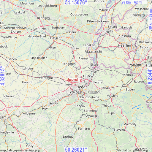
Juprelle GPS coordinates[2]
50° 42' 27.36" North, 5° 31' 52.572" East
| Map corner | latitude | longitude |
|---|---|---|
| Upper-left | 51.15076°, | 4.82815° |
| Center: | 50.7076°, | 5.53127° |
| Lower-right: | 50.26021°, | 6.2344° |
| Map W x H: | 99×99 km | = 61.5×61.5mi |
| max Lat: | 51.46791° ⇑58.5% North |
| Juprelle: | 50.7076° |
| min Lat: | ⇓41.5% South 49.53771° |
| min Long | Juprelle | max Long |
| 2.59368° | 5.53127° | 6.25749° |
| W 85.9%⇐ | ⇒14.1% E |
Elevation
Elevation of Juprelle is 147 m = 482 ft, and this is 47.5 m = 156 ft above average elevation for this country.
| Max E: |
582 m = 1909 ft | 24.9% |
| Juprelle | 147 m 482 ft | |
| Avg. | 99.5 m = 326 ft | |
Min E: |
1 m = 3 ft | 75.1% |
See also: Belgium elevation on elevation.city.
Geographical zone
Juprelle is located in North temperate zone (between Tropic of Cancer and the Arctic Circle). Distance of this North polar circle is 1763 km =1095.5 mi to North.| Distance of | km | miles | from Juprelle |
|---|---|---|---|
| North Pole | 4368.9 | 2714.7 | to North |
| Arctic Circle | 1763 | 1095.5 | to North |
| Tropic Cancer | 3032.2 | 1884.1 | to South |
| Equator | 5638.2 | 3503.4 | to South |


Nearby cities:
15 places around Juprelle: (largest is in red/bold)
• Ans
5.1 km =3.2 mi,  188°
188°
• Awans
6.5 km =4 mi,  227°
227°
• Bassenge
7.9 km =4.9 mi,  44°
44°
• Beyne-Heusay
13.4 km =8.3 mi,  135°
135°
• Crisnée
9.4 km =5.8 mi,  276°
276°
• Fexhe-le-Haut-Clocher
10.4 km =6.5 mi,  243°
243°
• Herstal
8.1 km =5 mi,  126°
126°
• Liège
8.6 km =5.3 mi,  162°
162°
• Mons-lez-Liège
11.1 km =6.9 mi,  204°
204°
• Oreye
12.9 km =8 mi,  274°
274°
• Oupeye
8.1 km =5 mi,  86°
86°
• Riemst
12.4 km =7.7 mi,  23°
23°
• Saint-Nicolas
8.8 km =5.5 mi,  179°
179°
• Tongeren
9.4 km =5.8 mi,  330°
330°
• Visé
12.3 km =7.6 mi,  74°
74°
Sources, notices
• [Note1] Compared only with cities in Belgium existing in our database
• [Src1] Map data: © OpenStreetMap contributors (CC-BY-SA)
• [Src2] Other city data from geonames.org with taken over terms of usage.
• [Src3] Geographical zone / Annual Mean Temperature by Robert A. Rohde @ Wikipedia
