Arendonk geodata
Arendonk (Flanders) is a populated place; located in Belgium in Europe/Brussels (GMT+2) time zone. With population of 12,247 people, there are 240 cities with bigger population in this country. Compared to other cities in Belgium, 97.8% of cities are located further ↓South; 69.1% of cities are located further ←West and 65.9% of cities have higher elevation than Arendonk. Note1
Administrative division(s):
- Level 1: Flanders
- Level 2: Provincie Antwerpen
- Level 3: Arrondissement Turnhout
- Level 4: Arendonk


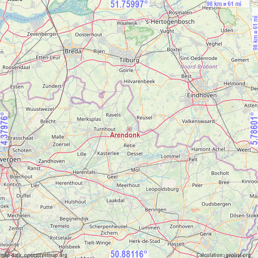
Arendonk GPS coordinates[2]
51° 19' 21.612" North, 5° 4' 58.404" East
| Map corner | latitude | longitude |
|---|---|---|
| Upper-left | 51.75997°, | 4.37976° |
| Center: | 51.32267°, | 5.08289° |
| Lower-right: | 50.88116°, | 5.78601° |
| Map W x H: | 97.7×97.7 km | = 60.7×60.7mi |
| max Lat: | 51.46791° ⇑2.2% North |
| Arendonk: | 51.32267° |
| min Lat: | ⇓97.8% South 49.53771° |
| min Long | Arendonk | max Long |
| 2.59368° | 5.08289° | 6.25749° |
| W 69.1%⇐ | ⇒30.9% E |
Elevation
Elevation of Arendonk is 25 m = 82 ft, and this is 74.5 m = 244 ft below average elevation for this country.
| Max E: |
582 m = 1909 ft | 65.9% |
| Avg. | 99.5 m = 326 ft | |
| Arendonk | 25 m = 82 ft | |
Min E: |
1 m = 3 ft | 34.1% |
See also: Belgium elevation on elevation.city.
Geographical zone
Arendonk is located in North temperate zone (between Tropic of Cancer and the Arctic Circle). Distance of this North polar circle is 1694.6 km =1053 mi to North.| Distance of | km | miles | from Arendonk |
|---|---|---|---|
| North Pole | 4300.5 | 2672.2 | to North |
| Arctic Circle | 1694.6 | 1053 | to North |
| Tropic Cancer | 3100.6 | 1926.6 | to South |
| Equator | 5706.5 | 3545.9 | to South |


Nearby cities:
15 places around Arendonk: (largest is in red/bold)
• Baarle-Hertog
16.1 km =10 mi,  304°
304°
• Balen
18.2 km =11.3 mi,  160°
160°
• Beerse
16 km =9.9 mi,  268°
268°
• Dessel
9.6 km =6 mi,  166°
166°
• Geel
18.6 km =11.6 mi,  200°
200°
• Kasterlee
12.1 km =7.5 mi,  221°
221°
• Lille
20.2 km =12.6 mi,  243°
243°
• Lommel
19 km =11.8 mi,  122°
122°
• Merksplas
15.6 km =9.7 mi,  284°
284°
• Mol
14.7 km =9.1 mi, 170°
• Oud-Turnhout
6.9 km =4.3 mi, 267°
• Ravels
8.4 km =5.2 mi,  311°
311°
• Retie
6.2 km =3.9 mi,  180°
180°
• Turnhout
9.6 km =6 mi, 269°
• Vosselaar
13.5 km =8.4 mi,  263°
263°
Sources, notices
• [Note1] Compared only with cities in Belgium existing in our database
• [Src1] Map data: © OpenStreetMap contributors (CC-BY-SA)
• [Src2] Other city data from geonames.org with taken over terms of usage.
• [Src3] Geographical zone / Annual Mean Temperature by Robert A. Rohde @ Wikipedia
