Kasterlee geodata
Kasterlee (Flanders) is a populated place; located in Belgium in Europe/Brussels (GMT+2) time zone. With population of 17,765 people, there are 145 cities with bigger population in this country. Compared to other cities in Belgium, 94.4% of cities are located further ↓South; 64.4% of cities are located further ←West and 70% of cities have higher elevation than Kasterlee. Note1
Administrative division(s):
- Level 1: Flanders
- Level 2: Provincie Antwerpen
- Level 3: Arrondissement Turnhout
- Level 4: Kasterlee


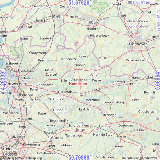
Kasterlee GPS coordinates[2]
51° 14' 28.248" North, 4° 57' 59.436" East
| Map corner | latitude | longitude |
|---|---|---|
| Upper-left | 51.67926°, | 4.26339° |
| Center: | 51.24118°, | 4.96651° |
| Lower-right: | 50.79888°, | 5.66964° |
| Map W x H: | 97.9×97.9 km | = 60.8×60.8mi |
| max Lat: | 51.46791° ⇑5.6% North |
| Kasterlee: | 51.24118° |
| min Lat: | ⇓94.4% South 49.53771° |
| min Long | Kasterlee | max Long |
| 2.59368° | 4.96651° | 6.25749° |
| W 64.4%⇐ | ⇒35.6% E |
Elevation
Elevation of Kasterlee is 22 m = 72 ft, and this is 77.5 m = 254 ft below average elevation for this country.
| Max E: |
582 m = 1909 ft | 70% |
| Avg. | 99.5 m = 326 ft | |
| Kasterlee | 22 m = 72 ft | |
Min E: |
1 m = 3 ft | 30% |
See also: Belgium elevation on elevation.city.
Geographical zone
Kasterlee is located in North temperate zone (between Tropic of Cancer and the Arctic Circle). Distance of this North polar circle is 1703.7 km =1058.6 mi to North.| Distance of | km | miles | from Kasterlee |
|---|---|---|---|
| North Pole | 4309.6 | 2677.9 | to North |
| Arctic Circle | 1703.7 | 1058.6 | to North |
| Tropic Cancer | 3091.6 | 1921 | to South |
| Equator | 5697.5 | 3540.3 | to South |


Nearby cities:
15 places around Kasterlee: (largest is in red/bold)
• Arendonk
12.1 km =7.5 mi,  41°
41°
• Beerse
11.7 km =7.3 mi,  317°
317°
• Dessel
10.3 km =6.4 mi,  91°
91°
• Geel
8.6 km =5.3 mi,  169°
169°
• Herentals
11.8 km =7.3 mi,  232°
232°
• Lille
10 km =6.2 mi,  270°
270°
• Meerhout
14.4 km =8.9 mi,  147°
147°
• Mol
11.8 km =7.3 mi,  117°
117°
• Olen
13.1 km =8.1 mi,  214°
214°
• Oud-Turnhout
8.8 km =5.5 mi,  7°
7°
• Ravels
14.7 km =9.1 mi, 6°
• Retie
8.5 km =5.3 mi,  70°
70°
• Turnhout
9.2 km =5.7 mi,  350°
350°
• Vorselaar
14.2 km =8.8 mi,  252°
252°
• Vosselaar
9.2 km =5.7 mi, 324°
Sources, notices
• [Note1] Compared only with cities in Belgium existing in our database
• [Src1] Map data: © OpenStreetMap contributors (CC-BY-SA)
• [Src2] Other city data from geonames.org with taken over terms of usage.
• [Src3] Geographical zone / Annual Mean Temperature by Robert A. Rohde @ Wikipedia
