Lontzen geodata
Lontzen (Wallonia) is a populated place; located in Belgium in Europe/Brussels (GMT+2) time zone. With population of 4,862 people, there are 460 cities with bigger population in this country. Compared to other cities in Belgium, 60.6% of cities are located further ↑North; 98.4% of cities are located further ←West and 85% of cities have lower elevation than Lontzen. Note1
Administrative division(s):
- Level 1: Wallonia
- Level 2: Province de Liège
- Level 3: Arrondissement de Verviers
- Level 4: Lontzen


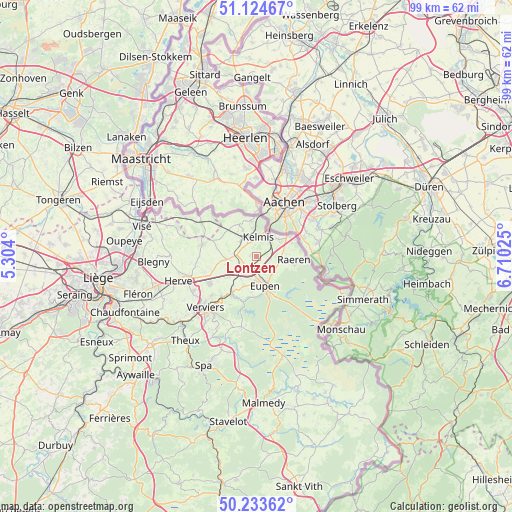
Lontzen GPS coordinates[2]
50° 40' 52.536" North, 6° 0' 25.632" East
| Map corner | latitude | longitude |
|---|---|---|
| Upper-left | 51.12467°, | 5.304° |
| Center: | 50.68126°, | 6.00712° |
| Lower-right: | 50.23362°, | 6.71025° |
| Map W x H: | 99.1×99.1 km | = 61.6×61.6mi |
| max Lat: | 51.46791° ⇑60.6% North |
| Lontzen: | 50.68126° |
| min Lat: | ⇓39.4% South 49.53771° |
| min Long | Lontzen | max Long |
| 2.59368° | 6.00712° | 6.25749° |
| W 98.4%⇐ | ⇒1.6% E |
Elevation
Elevation of Lontzen is 223 m = 732 ft, and this is 123.5 m = 405 ft above average elevation for this country.
| Max E: |
582 m = 1909 ft | 15% |
| Lontzen | 223 m 732 ft | |
| Avg. | 99.5 m = 326 ft | |
Min E: |
1 m = 3 ft | 85% |
See also: Belgium elevation on elevation.city.
Geographical zone
Lontzen is located in North temperate zone (between Tropic of Cancer and the Arctic Circle). Distance of this North polar circle is 1765.9 km =1097.3 mi to North.| Distance of | km | miles | from Lontzen |
|---|---|---|---|
| North Pole | 4371.8 | 2716.5 | to North |
| Arctic Circle | 1765.9 | 1097.3 | to North |
| Tropic Cancer | 3029.3 | 1882.3 | to South |
| Equator | 5635.2 | 3501.5 | to South |


Nearby cities:
15 places around Lontzen: (largest is in red/bold)
• Aubel
10.7 km =6.6 mi,  282°
282°
• Baelen
6 km =3.7 mi,  202°
202°
• Dison
13.4 km =8.3 mi,  233°
233°
• Eupen
6.3 km =3.9 mi,  160°
160°
• Herve
15.7 km =9.8 mi,  253°
253°
• Jalhay
13.9 km =8.6 mi,  191°
191°
• La Calamine
4.1 km =2.5 mi,  3°
3°
• Limbourg
9 km =5.6 mi,  211°
211°
• Pepinster
18.6 km =11.6 mi, 230°
• Plombières
7 km =4.3 mi,  331°
331°
• Raeren
7.8 km =4.8 mi,  101°
101°
• Sint-Pieters-Voeren
14.5 km =9 mi,  296°
296°
• Soumagne
19.8 km =12.3 mi, 247°
• Verviers
14.5 km =9 mi,  224°
224°
• Welkenraedt
3.5 km =2.2 mi, 228°
Sources, notices
• [Note1] Compared only with cities in Belgium existing in our database
• [Src1] Map data: © OpenStreetMap contributors (CC-BY-SA)
• [Src2] Other city data from geonames.org with taken over terms of usage.
• [Src3] Geographical zone / Annual Mean Temperature by Robert A. Rohde @ Wikipedia
