Plombières geodata
Plombières (Wallonia) is a populated place; located in Belgium in Europe/Brussels (GMT+2) time zone. With population of 9,596 people, there are 311 cities with bigger population in this country. Compared to other cities in Belgium, 55.4% of cities are located further ↑North; 97.7% of cities are located further ←West and 78.2% of cities have lower elevation than Plombières. Note1
Administrative division(s):
- Level 1: Wallonia
- Level 2: Province de Liège
- Level 3: Arrondissement de Verviers
- Level 4: Plombières


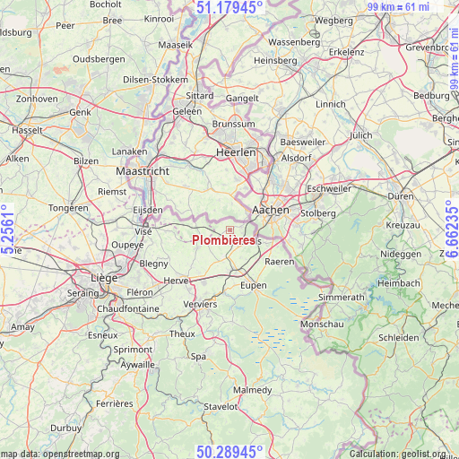
Plombières GPS coordinates[2]
50° 44' 11.616" North, 5° 57' 33.192" East
| Map corner | latitude | longitude |
|---|---|---|
| Upper-left | 51.17945°, | 5.2561° |
| Center: | 50.73656°, | 5.95922° |
| Lower-right: | 50.28945°, | 6.66235° |
| Map W x H: | 99×99 km | = 61.5×61.5mi |
| max Lat: | 51.46791° ⇑55.4% North |
| Plombières: | 50.73656° |
| min Lat: | ⇓44.6% South 49.53771° |
| min Long | Plombières | max Long |
| 2.59368° | 5.95922° | 6.25749° |
| W 97.7%⇐ | ⇒2.3% E |
Elevation
Elevation of Plombières is 167 m = 548 ft, and this is 67.5 m = 221 ft above average elevation for this country.
| Max E: |
582 m = 1909 ft | 21.8% |
| Plombières | 167 m 548 ft | |
| Avg. | 99.5 m = 326 ft | |
Min E: |
1 m = 3 ft | 78.2% |
See also: Belgium elevation on elevation.city.
Geographical zone
Plombières is located in North temperate zone (between Tropic of Cancer and the Arctic Circle). Distance of this North polar circle is 1759.8 km =1093.5 mi to North.| Distance of | km | miles | from Plombières |
|---|---|---|---|
| North Pole | 4365.7 | 2712.7 | to North |
| Arctic Circle | 1759.8 | 1093.5 | to North |
| Tropic Cancer | 3035.5 | 1886.2 | to South |
| Equator | 5641.4 | 3505.4 | to South |


Nearby cities:
15 places around Plombières: (largest is in red/bold)
• Aubel
8.1 km =5 mi,  241°
241°
• Baelen
11.8 km =7.3 mi,  174°
174°
• Blégny
18 km =11.2 mi,  246°
246°
• Dalhem
16.5 km =10.3 mi,  260°
260°
• Dison
15.9 km =9.9 mi,  207°
207°
• Eupen
13.3 km =8.3 mi,  155°
155°
• Herve
15.8 km =9.8 mi,  227°
227°
• La Calamine
4.2 km =2.6 mi,  119°
119°
• Limbourg
13.9 km =8.6 mi,  185°
185°
• Lontzen
7 km =4.3 mi,  151°
151°
• Raeren
13.4 km =8.3 mi,  125°
125°
• Sint-Pieters-Voeren
9.6 km =6 mi,  271°
271°
• Verviers
17.8 km =11.1 mi,  202°
202°
• Visé
18.3 km =11.4 mi, 270°
• Welkenraedt
8.5 km =5.3 mi, 174°
Sources, notices
• [Note1] Compared only with cities in Belgium existing in our database
• [Src1] Map data: © OpenStreetMap contributors (CC-BY-SA)
• [Src2] Other city data from geonames.org with taken over terms of usage.
• [Src3] Geographical zone / Annual Mean Temperature by Robert A. Rohde @ Wikipedia
