La Calamine geodata
La Calamine (Wallonia) is a populated place; located in Belgium in Europe/Brussels (GMT+2) time zone. With population of 10,232 people, there are 300 cities with bigger population in this country. Compared to other cities in Belgium, 56.5% of cities are located further ↑North; 98.6% of cities are located further ←West and 84.7% of cities have lower elevation than La Calamine. Note1
Administrative division(s):
- Level 1: Wallonia
- Level 2: Province de Liège
- Level 3: Arrondissement de Verviers
- Level 4: La Calamine


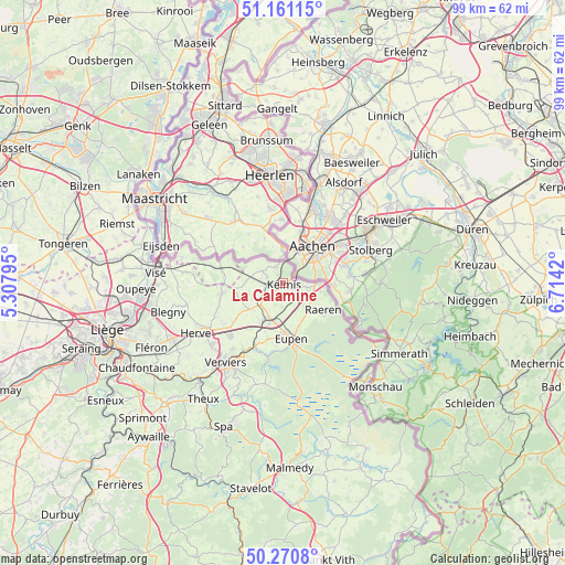
La Calamine GPS coordinates[2]
50° 43' 5.124" North, 6° 0' 39.852" East
| Map corner | latitude | longitude |
|---|---|---|
| Upper-left | 51.16115°, | 5.30795° |
| Center: | 50.71809°, | 6.01107° |
| Lower-right: | 50.2708°, | 6.7142° |
| Map W x H: | 99×99 km | = 61.5×61.5mi |
| max Lat: | 51.46791° ⇑56.5% North |
| La Calamine: | 50.71809° |
| min Lat: | ⇓43.5% South 49.53771° |
| min Long | La Calamine | max Long |
| 2.59368° | 6.01107° | 6.25749° |
| W 98.6%⇐ | ⇒1.4% E |
Elevation
Elevation of La Calamine is 220 m = 722 ft, and this is 120.5 m = 395 ft above average elevation for this country.
| Max E: |
582 m = 1909 ft | 15.3% |
| La Calamine | 220 m 722 ft | |
| Avg. | 99.5 m = 326 ft | |
Min E: |
1 m = 3 ft | 84.7% |
See also: Belgium elevation on elevation.city.
Geographical zone
La Calamine is located in North temperate zone (between Tropic of Cancer and the Arctic Circle). Distance of this North polar circle is 1761.9 km =1094.8 mi to North.| Distance of | km | miles | from La Calamine |
|---|---|---|---|
| North Pole | 4367.7 | 2714 | to North |
| Arctic Circle | 1761.9 | 1094.8 | to North |
| Tropic Cancer | 3033.4 | 1884.9 | to South |
| Equator | 5639.3 | 3504.1 | to South |


Nearby cities:
15 places around La Calamine: (largest is in red/bold)
• Aubel
10.9 km =6.8 mi,  260°
260°
• Baelen
10 km =6.2 mi,  195°
195°
• Blégny
20.8 km =12.9 mi, 255°
• Dalhem
20 km =12.4 mi,  268°
268°
• Dison
16.4 km =10.2 mi,  222°
222°
• Eupen
10.2 km =6.3 mi,  169°
169°
• Herve
17.6 km =10.9 mi,  240°
240°
• Jalhay
18 km =11.2 mi,  189°
189°
• Limbourg
12.8 km =8 mi, 202°
• Lontzen
4.1 km =2.5 mi,  183°
183°
• Plombières
4.2 km =2.6 mi,  299°
299°
• Raeren
9.3 km =5.8 mi,  127°
127°
• Sint-Pieters-Voeren
13.5 km =8.4 mi,  279°
279°
• Verviers
17.8 km =11.1 mi, 216°
• Welkenraedt
7 km =4.3 mi, 204°
Sources, notices
• [Note1] Compared only with cities in Belgium existing in our database
• [Src1] Map data: © OpenStreetMap contributors (CC-BY-SA)
• [Src2] Other city data from geonames.org with taken over terms of usage.
• [Src3] Geographical zone / Annual Mean Temperature by Robert A. Rohde @ Wikipedia
