Putte geodata
Putte (Flanders) is a populated place; located in Belgium in Europe/Brussels (GMT+2) time zone. With population of 15,276 people, there are 181 cities with bigger population in this country. Compared to other cities in Belgium, 76% of cities are located further ↓South; 52.3% of cities are located further ←West and 70% of cities have higher elevation than Putte. Note1
Administrative division(s):
- Level 1: Flanders
- Level 2: Provincie Antwerpen
- Level 3: Arrondissement Mechelen
- Level 4: Putte


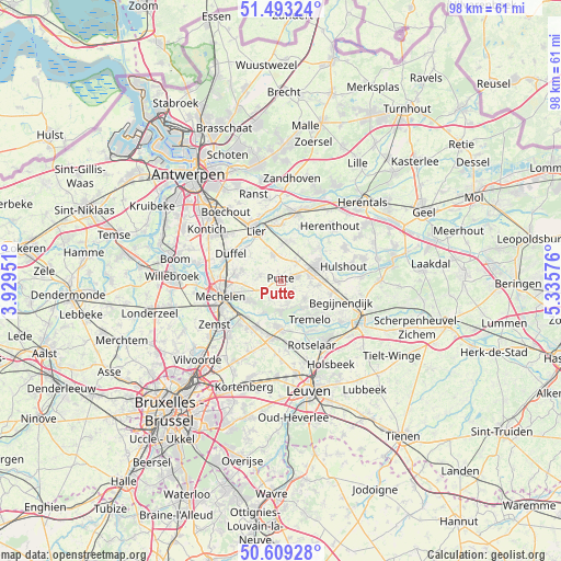
Putte GPS coordinates[2]
51° 3' 12.132" North, 4° 37' 57.468" East
| Map corner | latitude | longitude |
|---|---|---|
| Upper-left | 51.49324°, | 3.92951° |
| Center: | 51.05337°, | 4.63263° |
| Lower-right: | 50.60928°, | 5.33576° |
| Map W x H: | 98.3×98.3 km | = 61.1×61.1mi |
| max Lat: | 51.46791° ⇑24% North |
| Putte: | 51.05337° |
| min Lat: | ⇓76% South 49.53771° |
| min Long | Putte | max Long |
| 2.59368° | 4.63263° | 6.25749° |
| W 52.3%⇐ | ⇒47.7% E |
Elevation
Elevation of Putte is 22 m = 72 ft, and this is 77.5 m = 254 ft below average elevation for this country.
| Max E: |
582 m = 1909 ft | 70% |
| Avg. | 99.5 m = 326 ft | |
| Putte | 22 m = 72 ft | |
Min E: |
1 m = 3 ft | 30% |
See also: Belgium elevation on elevation.city.
Geographical zone
Putte is located in North temperate zone (between Tropic of Cancer and the Arctic Circle). Distance of this North polar circle is 1724.6 km =1071.6 mi to North.| Distance of | km | miles | from Putte |
|---|---|---|---|
| North Pole | 4330.5 | 2690.8 | to North |
| Arctic Circle | 1724.6 | 1071.6 | to North |
| Tropic Cancer | 3070.7 | 1908 | to South |
| Equator | 5676.6 | 3527.3 | to South |


Nearby cities:
15 places around Putte: (largest is in red/bold)
• Begijnendijk
11.2 km =7 mi,  109°
109°
• Berlaar
7.4 km =4.6 mi,  14°
14°
• Bonheiden
6.9 km =4.3 mi,  240°
240°
• Boortmeerbeek
9.2 km =5.7 mi,  206°
206°
• Duffel
9.8 km =6.1 mi,  298°
298°
• Haacht
8.5 km =5.3 mi,  177°
177°
• Heist-op-den-Berg
7.1 km =4.4 mi,  69°
69°
• Hulshout
11.3 km =7 mi,  77°
77°
• Keerbergen
5.6 km =3.5 mi, 178°
• Lier
9.7 km =6 mi,  333°
333°
• Lint
12.5 km =7.8 mi,  310°
310°
• Mechelen
11.3 km =7 mi,  254°
254°
• Nijlen
12.2 km =7.6 mi, 12°
• Sint-Katelijne-Waver
7 km =4.3 mi,  282°
282°
• Tremelo
8.6 km =5.3 mi,  142°
142°
Sources, notices
• [Note1] Compared only with cities in Belgium existing in our database
• [Src1] Map data: © OpenStreetMap contributors (CC-BY-SA)
• [Src2] Other city data from geonames.org with taken over terms of usage.
• [Src3] Geographical zone / Annual Mean Temperature by Robert A. Rohde @ Wikipedia
