Meerhout geodata
Meerhout (Flanders) is a populated place; located in Belgium in Europe/Brussels (GMT+2) time zone. With population of 9,346 people, there are 320 cities with bigger population in this country. Compared to other cities in Belgium, 83.8% of cities are located further ↓South; 68.4% of cities are located further ←West and 62.3% of cities have higher elevation than Meerhout. Note1
Administrative division(s):
- Level 1: Flanders
- Level 2: Provincie Antwerpen
- Level 3: Arrondissement Turnhout
- Level 4: Meerhout


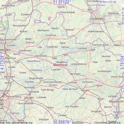
Meerhout GPS coordinates[2]
51° 7' 55.56" North, 5° 4' 42.312" East
| Map corner | latitude | longitude |
|---|---|---|
| Upper-left | 51.57122°, | 4.37529° |
| Center: | 51.1321°, | 5.07842° |
| Lower-right: | 50.68876°, | 5.78154° |
| Map W x H: | 98.1×98.1 km | = 61×61mi |
| max Lat: | 51.46791° ⇑16.2% North |
| Meerhout: | 51.1321° |
| min Lat: | ⇓83.8% South 49.53771° |
| min Long | Meerhout | max Long |
| 2.59368° | 5.07842° | 6.25749° |
| W 68.4%⇐ | ⇒31.6% E |
Elevation
Elevation of Meerhout is 30 m = 98 ft, and this is 69.5 m = 228 ft below average elevation for this country.
| Max E: |
582 m = 1909 ft | 62.3% |
| Avg. | 99.5 m = 326 ft | |
| Meerhout | 30 m = 98 ft | |
Min E: |
1 m = 3 ft | 37.7% |
See also: Belgium elevation on elevation.city.
Geographical zone
Meerhout is located in North temperate zone (between Tropic of Cancer and the Arctic Circle). Distance of this North polar circle is 1715.8 km =1066.1 mi to North.| Distance of | km | miles | from Meerhout |
|---|---|---|---|
| North Pole | 4321.7 | 2685.4 | to North |
| Arctic Circle | 1715.8 | 1066.1 | to North |
| Tropic Cancer | 3079.4 | 1913.4 | to South |
| Equator | 5685.4 | 3532.7 | to South |


Nearby cities:
15 places around Meerhout: (largest is in red/bold)
• Balen
7.6 km =4.7 mi,  57°
57°
• Beringen
13.8 km =8.6 mi,  131°
131°
• Dessel
12.1 km =7.5 mi,  11°
11°
• Diest
16 km =9.9 mi,  186°
186°
• Geel
7.3 km =4.5 mi,  300°
300°
• Herselt
16.4 km =10.2 mi,  236°
236°
• Kasterlee
14.4 km =8.9 mi,  327°
327°
• Laakdal
7.7 km =4.8 mi,  221°
221°
• Leopoldsburg
12.1 km =7.5 mi,  98°
98°
• Mol
7.2 km =4.5 mi,  21°
21°
• Olen
15.3 km =9.5 mi,  274°
274°
• Retie
14.9 km =9.3 mi,  1°
1°
• Scherpenheuvel-Zichem
15.3 km =9.5 mi,  208°
208°
• Tessenderlo
7.5 km =4.7 mi,  174°
174°
• Westerlo
12.3 km =7.6 mi,  247°
247°
Sources, notices
• [Note1] Compared only with cities in Belgium existing in our database
• [Src1] Map data: © OpenStreetMap contributors (CC-BY-SA)
• [Src2] Other city data from geonames.org with taken over terms of usage.
• [Src3] Geographical zone / Annual Mean Temperature by Robert A. Rohde @ Wikipedia
