Mol geodata
Mol (Flanders) is a populated place; located in Belgium in Europe/Brussels (GMT+2) time zone. With population of 32,659 people, there are 47 cities with bigger population in this country. Compared to other cities in Belgium, 90.1% of cities are located further ↓South; 70.9% of cities are located further ←West and 64.3% of cities have higher elevation than Mol. Note1
Administrative division(s):
- Level 1: Flanders
- Level 2: Provincie Antwerpen
- Level 3: Arrondissement Turnhout
- Level 4: Mol


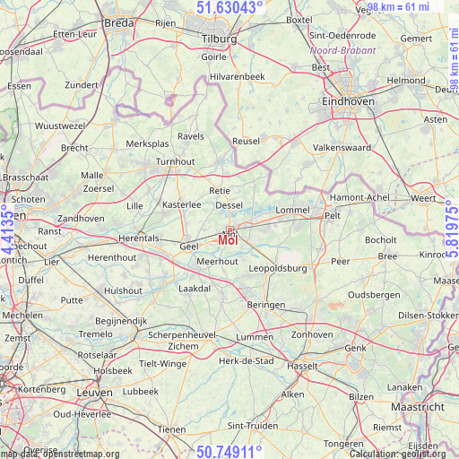
Mol GPS coordinates[2]
51° 11' 30.768" North, 5° 6' 59.832" East
| Map corner | latitude | longitude |
|---|---|---|
| Upper-left | 51.63043°, | 4.4135° |
| Center: | 51.19188°, | 5.11662° |
| Lower-right: | 50.74911°, | 5.81975° |
| Map W x H: | 98×98 km | = 60.9×60.9mi |
| max Lat: | 51.46791° ⇑9.9% North |
| Mol: | 51.19188° |
| min Lat: | ⇓90.1% South 49.53771° |
| min Long | Mol | max Long |
| 2.59368° | 5.11662° | 6.25749° |
| W 70.9%⇐ | ⇒29.1% E |
Elevation
Elevation of Mol is 27 m = 89 ft, and this is 72.5 m = 238 ft below average elevation for this country.
| Max E: |
582 m = 1909 ft | 64.3% |
| Avg. | 99.5 m = 326 ft | |
| Mol | 27 m = 89 ft | |
Min E: |
1 m = 3 ft | 35.7% |
See also: Belgium elevation on elevation.city.
Geographical zone
Mol is located in North temperate zone (between Tropic of Cancer and the Arctic Circle). Distance of this North polar circle is 1709.2 km =1062 mi to North.| Distance of | km | miles | from Mol |
|---|---|---|---|
| North Pole | 4315.1 | 2681.3 | to North |
| Arctic Circle | 1709.2 | 1062 | to North |
| Tropic Cancer | 3086.1 | 1917.6 | to South |
| Equator | 5692 | 3536.8 | to South |


Nearby cities:
15 places around Mol: (largest is in red/bold)
• Arendonk
14.7 km =9.1 mi,  350°
350°
• Balen
4.6 km =2.9 mi,  124°
124°
• Beringen
17.6 km =10.9 mi,  154°
154°
• Dessel
5.2 km =3.2 mi,  358°
358°
• Geel
9.4 km =5.8 mi,  251°
251°
• Kasterlee
11.8 km =7.3 mi,  297°
297°
• Laakdal
14.6 km =9.1 mi,  212°
212°
• Leopoldsburg
12.5 km =7.8 mi,  131°
131°
• Lommel
14.4 km =8.9 mi,  72°
72°
• Meerhout
7.2 km =4.5 mi,  201°
201°
• Olen
18.7 km =11.6 mi, 253°
• Oud-Turnhout
16.9 km =10.5 mi,  327°
327°
• Retie
8.6 km =5.3 mi,  343°
343°
• Tessenderlo
14.2 km =8.8 mi,  187°
187°
• Westerlo
18 km =11.2 mi,  231°
231°
Sources, notices
• [Note1] Compared only with cities in Belgium existing in our database
• [Src1] Map data: © OpenStreetMap contributors (CC-BY-SA)
• [Src2] Other city data from geonames.org with taken over terms of usage.
• [Src3] Geographical zone / Annual Mean Temperature by Robert A. Rohde @ Wikipedia
