Hoeselt geodata
Hoeselt (Flanders) is a populated place; located in Belgium in Europe/Brussels (GMT+2) time zone. With population of 9,265 people, there are 323 cities with bigger population in this country. Compared to other cities in Belgium, 53.8% of cities are located further ↓South; 83.9% of cities are located further ←West and 59.2% of cities have lower elevation than Hoeselt. Note1
Administrative division(s):
- Level 1: Flanders
- Level 2: Provincie Limburg
- Level 3: Arrondissement Tongeren
- Level 4: Hoeselt


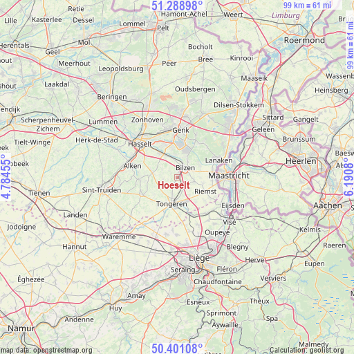
Hoeselt GPS coordinates[2]
50° 50' 49.704" North, 5° 29' 15.612" East
| Map corner | latitude | longitude |
|---|---|---|
| Upper-left | 51.28898°, | 4.78455° |
| Center: | 50.84714°, | 5.48767° |
| Lower-right: | 50.40108°, | 6.1908° |
| Map W x H: | 98.7×98.7 km | = 61.3×61.3mi |
| max Lat: | 51.46791° ⇑46.2% North |
| Hoeselt: | 50.84714° |
| min Lat: | ⇓53.8% South 49.53771° |
| min Long | Hoeselt | max Long |
| 2.59368° | 5.48767° | 6.25749° |
| W 83.9%⇐ | ⇒16.1% E |
Elevation
Elevation of Hoeselt is 77 m = 253 ft, and this is 22.5 m = 74 ft below average elevation for this country.
| Max E: |
582 m = 1909 ft | 40.8% |
| Avg. | 99.5 m = 326 ft | |
| Hoeselt | 77 m = 253 ft | |
Min E: |
1 m = 3 ft | 59.2% |
See also: Belgium elevation on elevation.city.
Geographical zone
Hoeselt is located in North temperate zone (between Tropic of Cancer and the Arctic Circle). Distance of this North polar circle is 1747.5 km =1085.8 mi to North.| Distance of | km | miles | from Hoeselt |
|---|---|---|---|
| North Pole | 4353.4 | 2705.1 | to North |
| Arctic Circle | 1747.5 | 1085.8 | to North |
| Tropic Cancer | 3047.8 | 1893.8 | to South |
| Equator | 5653.7 | 3513 | to South |


Nearby cities:
15 places around Hoeselt: (largest is in red/bold)
• Alken
13.2 km =8.2 mi,  283°
283°
• Bassenge
13 km =8.1 mi,  138°
138°
• Bilzen
3.6 km =2.2 mi,  36°
36°
• Borgloon
11.1 km =6.9 mi,  245°
245°
• Diepenbeek
8.3 km =5.2 mi,  324°
324°
• Genk
13.1 km =8.1 mi,  4°
4°
• Hasselt
14.1 km =8.8 mi,  311°
311°
• Juprelle
15.8 km =9.8 mi,  168°
168°
• Kortessem
7 km =4.3 mi, 280°
• Lanaken
12.3 km =7.6 mi,  65°
65°
• Riemst
9 km =5.6 mi,  117°
117°
• Sint-Joris
15.4 km =9.6 mi, 280°
• Tongeren
7.6 km =4.7 mi,  192°
192°
• Wellen
10.5 km =6.5 mi,  266°
266°
• Zutendaal
11.4 km =7.1 mi,  32°
32°
Sources, notices
• [Note1] Compared only with cities in Belgium existing in our database
• [Src1] Map data: © OpenStreetMap contributors (CC-BY-SA)
• [Src2] Other city data from geonames.org with taken over terms of usage.
• [Src3] Geographical zone / Annual Mean Temperature by Robert A. Rohde @ Wikipedia
