Borgloon geodata
Borgloon (Flanders) is a populated place; located in Belgium in Europe/Brussels (GMT+2) time zone. With population of 9,955 people, there are 304 cities with bigger population in this country. Compared to other cities in Belgium, 50.4% of cities are located further ↓South; 78.9% of cities are located further ←West and 65.5% of cities have lower elevation than Borgloon. Note1
Administrative division(s):
- Level 1: Flanders
- Level 2: Provincie Limburg
- Level 3: Arrondissement Tongeren
- Level 4: Borgloon


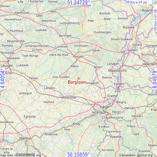
Borgloon GPS coordinates[2]
50° 48' 18.18" North, 5° 20' 37.176" East
| Map corner | latitude | longitude |
|---|---|---|
| Upper-left | 51.24729°, | 4.64054° |
| Center: | 50.80505°, | 5.34366° |
| Lower-right: | 50.35859°, | 6.04679° |
| Map W x H: | 98.8×98.8 km | = 61.4×61.4mi |
| max Lat: | 51.46791° ⇑49.6% North |
| Borgloon: | 50.80505° |
| min Lat: | ⇓50.4% South 49.53771° |
| min Long | Borgloon | max Long |
| 2.59368° | 5.34366° | 6.25749° |
| W 78.9%⇐ | ⇒21.1% E |
Elevation
Elevation of Borgloon is 98 m = 322 ft, and this is 1.5 m = 5 ft below average elevation for this country.
| Max E: |
582 m = 1909 ft | 34.5% |
| Avg. | 99.5 m = 326 ft | |
| Borgloon | 98 m = 322 ft | |
Min E: |
1 m = 3 ft | 65.5% |
See also: Belgium elevation on elevation.city.
Geographical zone
Borgloon is located in North temperate zone (between Tropic of Cancer and the Arctic Circle). Distance of this North polar circle is 1752.2 km =1088.8 mi to North.| Distance of | km | miles | from Borgloon |
|---|---|---|---|
| North Pole | 4358.1 | 2708 | to North |
| Arctic Circle | 1752.2 | 1088.8 | to North |
| Tropic Cancer | 3043.1 | 1890.9 | to South |
| Equator | 5649 | 3510.1 | to South |


Nearby cities:
15 places around Borgloon: (largest is in red/bold)
• Alken
8.3 km =5.2 mi,  341°
341°
• Crisnée
10.5 km =6.5 mi,  158°
158°
• Diepenbeek
12.6 km =7.8 mi,  24°
24°
• Heers
6.4 km =4 mi,  207°
207°
• Hoeselt
11.1 km =6.9 mi,  65°
65°
• Kortessem
6.8 km =4.2 mi,  28°
28°
• Nieuwerkerken
12.3 km =7.6 mi,  301°
301°
• Oreye
9.7 km =6 mi,  177°
177°
• Remicourt
13.9 km =8.6 mi, 184°
• Sint-Joris
8.9 km =5.5 mi,  325°
325°
• Sint-Truiden
11.1 km =6.9 mi,  276°
276°
• Terkoest
11.4 km =7.1 mi, 335°
• Tongeren
8.9 km =5.5 mi,  107°
107°
• Waremme
13.5 km =8.4 mi, 207°
• Wellen
4 km =2.5 mi,  354°
354°
Sources, notices
• [Note1] Compared only with cities in Belgium existing in our database
• [Src1] Map data: © OpenStreetMap contributors (CC-BY-SA)
• [Src2] Other city data from geonames.org with taken over terms of usage.
• [Src3] Geographical zone / Annual Mean Temperature by Robert A. Rohde @ Wikipedia
