Waremme geodata
Waremme (Wallonia) is a populated place; located in Belgium in Europe/Brussels (GMT+2) time zone. With population of 13,737 people, there are 208 cities with bigger population in this country. Compared to other cities in Belgium, 59.2% of cities are located further ↑North; 75.1% of cities are located further ←West and 69% of cities have lower elevation than Waremme. Note1
Administrative division(s):
- Level 1: Wallonia
- Level 2: Province de Liège
- Level 3: Arrondissement de Waremme
- Level 4: Waremme


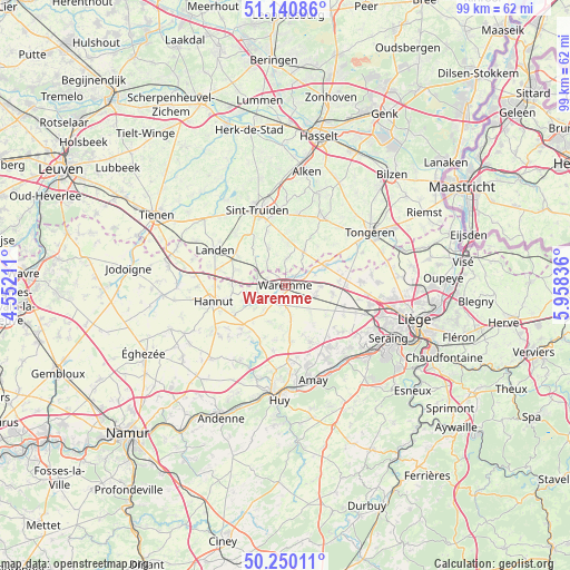
Waremme GPS coordinates[2]
50° 41' 51.36" North, 5° 15' 18.864" East
| Map corner | latitude | longitude |
|---|---|---|
| Upper-left | 51.14086°, | 4.55211° |
| Center: | 50.6976°, | 5.25524° |
| Lower-right: | 50.25011°, | 5.95836° |
| Map W x H: | 99×99 km | = 61.5×61.5mi |
| max Lat: | 51.46791° ⇑59.2% North |
| Waremme: | 50.6976° |
| min Lat: | ⇓40.8% South 49.53771° |
| min Long | Waremme | max Long |
| 2.59368° | 5.25524° | 6.25749° |
| W 75.1%⇐ | ⇒24.9% E |
Elevation
Elevation of Waremme is 117 m = 384 ft, and this is 17.5 m = 57 ft above average elevation for this country.
| Max E: |
582 m = 1909 ft | 31% |
| Waremme | 117 m 384 ft | |
| Avg. | 99.5 m = 326 ft | |
Min E: |
1 m = 3 ft | 69% |
See also: Belgium elevation on elevation.city.
Geographical zone
Waremme is located in North temperate zone (between Tropic of Cancer and the Arctic Circle). Distance of this North polar circle is 1764.1 km =1096.2 mi to North.| Distance of | km | miles | from Waremme |
|---|---|---|---|
| North Pole | 4370 | 2715.4 | to North |
| Arctic Circle | 1764.1 | 1096.2 | to North |
| Tropic Cancer | 3031.1 | 1883.4 | to South |
| Equator | 5637 | 3502.7 | to South |


Nearby cities:
15 places around Waremme: (largest is in red/bold)
• Berloz
3 km =1.9 mi,  271°
271°
• Borgloon
13.5 km =8.4 mi,  27°
27°
• Braives
12.4 km =7.7 mi,  224°
224°
• Crisnée
10.3 km =6.4 mi,  77°
77°
• Donceel
7.1 km =4.4 mi,  140°
140°
• Faimes
3.9 km =2.4 mi,  175°
175°
• Fexhe-le-Haut-Clocher
10.8 km =6.7 mi,  109°
109°
• Geer
6.5 km =4 mi,  241°
241°
• Gingelom
10.2 km =6.3 mi,  303°
303°
• Hannut
12.8 km =8 mi,  256°
256°
• Heers
7.1 km =4.4 mi, 27°
• Oreye
6.9 km =4.3 mi,  71°
71°
• Remicourt
5.4 km =3.4 mi, 110°
• Verlaine
10.9 km =6.8 mi,  156°
156°
• Villers-le-Bouillet
13.4 km =8.3 mi, 178°
Sources, notices
• [Note1] Compared only with cities in Belgium existing in our database
• [Src1] Map data: © OpenStreetMap contributors (CC-BY-SA)
• [Src2] Other city data from geonames.org with taken over terms of usage.
• [Src3] Geographical zone / Annual Mean Temperature by Robert A. Rohde @ Wikipedia
