Gingelom geodata
Gingelom (Flanders) is a populated place; located in Belgium in Europe/Brussels (GMT+2) time zone. With population of 7,930 people, there are 370 cities with bigger population in this country. Compared to other cities in Belgium, 53.8% of cities are located further ↑North; 71.7% of cities are located further ←West and 60.8% of cities have lower elevation than Gingelom. Note1
Administrative division(s):
- Level 1: Flanders
- Level 2: Provincie Limburg
- Level 3: Arrondissement Hasselt
- Level 4: Gingelom


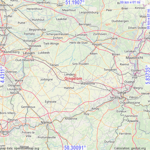
Gingelom GPS coordinates[2]
50° 44' 52.512" North, 5° 8' 3.192" East
| Map corner | latitude | longitude |
|---|---|---|
| Upper-left | 51.1907°, | 4.4311° |
| Center: | 50.74792°, | 5.13422° |
| Lower-right: | 50.30091°, | 5.83735° |
| Map W x H: | 98.9×98.9 km | = 61.5×61.5mi |
| max Lat: | 51.46791° ⇑53.8% North |
| Gingelom: | 50.74792° |
| min Lat: | ⇓46.2% South 49.53771° |
| min Long | Gingelom | max Long |
| 2.59368° | 5.13422° | 6.25749° |
| W 71.7%⇐ | ⇒28.3% E |
Elevation
Elevation of Gingelom is 83 m = 272 ft, and this is 16.5 m = 54 ft below average elevation for this country.
| Max E: |
582 m = 1909 ft | 39.2% |
| Avg. | 99.5 m = 326 ft | |
| Gingelom | 83 m = 272 ft | |
Min E: |
1 m = 3 ft | 60.8% |
See also: Belgium elevation on elevation.city.
Geographical zone
Gingelom is located in North temperate zone (between Tropic of Cancer and the Arctic Circle). Distance of this North polar circle is 1758.5 km =1092.7 mi to North.| Distance of | km | miles | from Gingelom |
|---|---|---|---|
| North Pole | 4364.4 | 2711.9 | to North |
| Arctic Circle | 1758.5 | 1092.7 | to North |
| Tropic Cancer | 3036.7 | 1886.9 | to South |
| Equator | 5642.6 | 3506.1 | to South |


Nearby cities:
15 places around Gingelom: (largest is in red/bold)
• Berloz
7.8 km =4.8 mi,  135°
135°
• Braives
14.5 km =9 mi,  180°
180°
• Faimes
13 km =8.1 mi, 136°
• Geer
9.1 km =5.7 mi,  162°
162°
• Hannut
9.4 km =5.8 mi,  204°
204°
• Heers
11.8 km =7.3 mi,  86°
86°
• Landen
3.7 km =2.3 mi,  278°
278°
• Lincent
7.9 km =4.9 mi,  239°
239°
• Nieuwerkerken
13.6 km =8.5 mi,  18°
18°
• Oreye
15.5 km =9.6 mi,  102°
102°
• Remicourt
15.5 km =9.6 mi,  118°
118°
• Sint-Truiden
8.5 km =5.3 mi,  25°
25°
• Tienen
15.3 km =9.5 mi,  295°
295°
• Waremme
10.2 km =6.3 mi, 123°
• Zoutleeuw
9.7 km =6 mi,  347°
347°
Sources, notices
• [Note1] Compared only with cities in Belgium existing in our database
• [Src1] Map data: © OpenStreetMap contributors (CC-BY-SA)
• [Src2] Other city data from geonames.org with taken over terms of usage.
• [Src3] Geographical zone / Annual Mean Temperature by Robert A. Rohde @ Wikipedia
