Lincent geodata
Lincent (Wallonia) is a seat of a fourth-order administrative division; located in Belgium in Europe/Brussels (GMT+2) time zone. With population of 2,884 people, there are 511 cities with bigger population in this country. Compared to other cities in Belgium, 57.9% of cities are located further ↑North; 67.3% of cities are located further ←West and 65.3% of cities have lower elevation than Lincent. Note1
Administrative division(s):
- Level 1: Wallonia
- Level 2: Province de Liège
- Level 3: Arrondissement de Waremme
- Level 4: Lincent


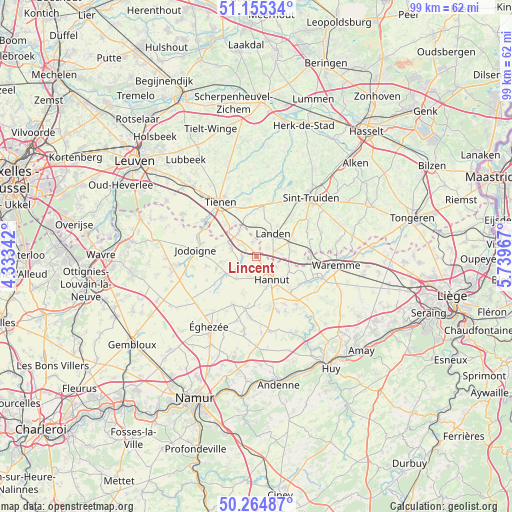
Lincent GPS coordinates[2]
50° 42' 43.992" North, 5° 2' 11.544" East
| Map corner | latitude | longitude |
|---|---|---|
| Upper-left | 51.15534°, | 4.33342° |
| Center: | 50.71222°, | 5.03654° |
| Lower-right: | 50.26487°, | 5.73967° |
| Map W x H: | 99×99 km | = 61.5×61.5mi |
| max Lat: | 51.46791° ⇑57.9% North |
| Lincent: | 50.71222° |
| min Lat: | ⇓42.1% South 49.53771° |
| min Long | Lincent | max Long |
| 2.59368° | 5.03654° | 6.25749° |
| W 67.3%⇐ | ⇒32.7% E |
Elevation
Elevation of Lincent is 97 m = 318 ft, and this is 2.5 m = 8 ft below average elevation for this country.
| Max E: |
582 m = 1909 ft | 34.7% |
| Avg. | 99.5 m = 326 ft | |
| Lincent | 97 m = 318 ft | |
Min E: |
1 m = 3 ft | 65.3% |
See also: Belgium elevation on elevation.city.
Geographical zone
Lincent is located in North temperate zone (between Tropic of Cancer and the Arctic Circle). Distance of this North polar circle is 1762.5 km =1095.2 mi to North.| Distance of | km | miles | from Lincent |
|---|---|---|---|
| North Pole | 4368.4 | 2714.4 | to North |
| Arctic Circle | 1762.5 | 1095.2 | to North |
| Tropic Cancer | 3032.8 | 1884.5 | to South |
| Equator | 5638.7 | 3503.7 | to South |


Nearby cities:
15 places around Lincent: (largest is in red/bold)
• Berloz
12.5 km =7.8 mi,  97°
97°
• Braives
12.5 km =7.8 mi,  147°
147°
• Burdinne
14.5 km =9 mi,  168°
168°
• Geer
10.7 km =6.6 mi,  115°
115°
• Gingelom
7.9 km =4.9 mi,  59°
59°
• Hannut
5.4 km =3.4 mi, 146°
• Hemptinne
12.6 km =7.8 mi,  195°
195°
• Hoegaarden
12.5 km =7.8 mi,  304°
304°
• Jodoigne
11.9 km =7.4 mi,  276°
276°
• Landen
5.5 km =3.4 mi,  35°
35°
• Ramillies
12.9 km =8 mi,  227°
227°
• Tienen
12.7 km =7.9 mi,  326°
326°
• Waremme
15.5 km =9.6 mi, 96°
• Wasseiges
10.3 km =6.4 mi,  192°
192°
• Zoutleeuw
14.3 km =8.9 mi,  19°
19°
Sources, notices
• [Note1] Compared only with cities in Belgium existing in our database
• [Src1] Map data: © OpenStreetMap contributors (CC-BY-SA)
• [Src2] Other city data from geonames.org with taken over terms of usage.
• [Src3] Geographical zone / Annual Mean Temperature by Robert A. Rohde @ Wikipedia
