Landen geodata
Landen (Flanders) is a populated place; located in Belgium in Europe/Brussels (GMT+2) time zone. With population of 14,458 people, there are 194 cities with bigger population in this country. Compared to other cities in Belgium, 53.6% of cities are located further ↑North; 68.8% of cities are located further ←West and 57.8% of cities have lower elevation than Landen. Note1
Administrative division(s):
- Level 1: Flanders
- Level 2: Provincie Vlaams-Brabant
- Level 3: Arrondissement Leuven
- Level 4: Landen


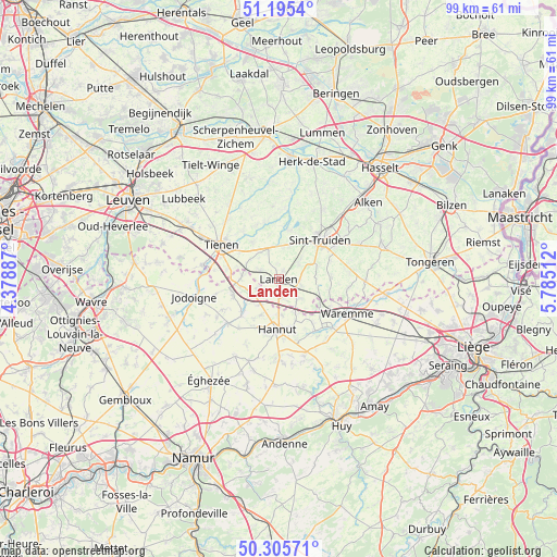
Landen GPS coordinates[2]
50° 45' 9.612" North, 5° 4' 55.2" East
| Map corner | latitude | longitude |
|---|---|---|
| Upper-left | 51.1954°, | 4.37887° |
| Center: | 50.75267°, | 5.082° |
| Lower-right: | 50.30571°, | 5.78512° |
| Map W x H: | 98.9×98.9 km | = 61.5×61.5mi |
| max Lat: | 51.46791° ⇑53.6% North |
| Landen: | 50.75267° |
| min Lat: | ⇓46.4% South 49.53771° |
| min Long | Landen | max Long |
| 2.59368° | 5.082° | 6.25749° |
| W 68.8%⇐ | ⇒31.2% E |
Elevation
Elevation of Landen is 72 m = 236 ft, and this is 27.5 m = 90 ft below average elevation for this country.
| Max E: |
582 m = 1909 ft | 42.2% |
| Avg. | 99.5 m = 326 ft | |
| Landen | 72 m = 236 ft | |
Min E: |
1 m = 3 ft | 57.8% |
See also: Belgium elevation on elevation.city.
Geographical zone
Landen is located in North temperate zone (between Tropic of Cancer and the Arctic Circle). Distance of this North polar circle is 1758 km =1092.4 mi to North.| Distance of | km | miles | from Landen |
|---|---|---|---|
| North Pole | 4363.9 | 2711.6 | to North |
| Arctic Circle | 1758 | 1092.4 | to North |
| Tropic Cancer | 3037.2 | 1887.2 | to South |
| Equator | 5643.2 | 3506.5 | to South |


Nearby cities:
15 places around Landen: (largest is in red/bold)
• Berloz
11 km =6.8 mi,  123°
123°
• Braives
15.5 km =9.6 mi,  166°
166°
• Geer
11.2 km =7 mi,  144°
144°
• Gingelom
3.7 km =2.3 mi,  98°
98°
• Hannut
9 km =5.6 mi,  181°
181°
• Heers
15.5 km =9.6 mi,  89°
89°
• Hoegaarden
13.8 km =8.6 mi,  280°
280°
• Jodoigne
15.3 km =9.5 mi,  257°
257°
• Lincent
5.5 km =3.4 mi,  215°
215°
• Nieuwerkerken
14.7 km =9.1 mi,  32°
32°
• Sint-Truiden
10.2 km =6.3 mi,  45°
45°
• Tienen
11.8 km =7.3 mi,  300°
300°
• Waremme
13.6 km =8.5 mi, 116°
• Wasseiges
15.5 km =9.6 mi,  200°
200°
• Zoutleeuw
9.1 km =5.7 mi,  9°
9°
Sources, notices
• [Note1] Compared only with cities in Belgium existing in our database
• [Src1] Map data: © OpenStreetMap contributors (CC-BY-SA)
• [Src2] Other city data from geonames.org with taken over terms of usage.
• [Src3] Geographical zone / Annual Mean Temperature by Robert A. Rohde @ Wikipedia
