Flémalle-Haute geodata
Flémalle-Haute (Wallonia) is a populated place; located in Belgium in Europe/Brussels (GMT+2) time zone. With population of 25,144 people, there are 79 cities with bigger population in this country. Compared to other cities in Belgium, 69.1% of cities are located further ↑North; 82.3% of cities are located further ←West and 79.8% of cities have lower elevation than Flémalle-Haute. Note1
Administrative division(s):
- Level 1: Wallonia
- Level 2: Province de Liège
- Level 3: Arrondissement de Liège
- Level 4: Flémalle


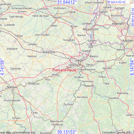
Flémalle-Haute GPS coordinates[2]
50° 35' 59.784" North, 5° 26' 40.956" East
| Map corner | latitude | longitude |
|---|---|---|
| Upper-left | 51.04412°, | 4.74159° |
| Center: | 50.59994°, | 5.44471° |
| Lower-right: | 50.15153°, | 6.14784° |
| Map W x H: | 99.2×99.2 km | = 61.6×61.6mi |
| max Lat: | 51.46791° ⇑69.1% North |
| Flémalle-Haute: | 50.59994° |
| min Lat: | ⇓30.9% South 49.53771° |
| min Long | Flémalle-Haute | max Long |
| 2.59368° | 5.44471° | 6.25749° |
| W 82.3%⇐ | ⇒17.7% E |
Elevation
Elevation of Flémalle-Haute is 175 m = 574 ft, and this is 75.5 m = 248 ft above average elevation for this country.
| Max E: |
582 m = 1909 ft | 20.2% |
| Flémalle-Haute | 175 m 574 ft | |
| Avg. | 99.5 m = 326 ft | |
Min E: |
1 m = 3 ft | 79.8% |
See also: Belgium elevation on elevation.city.
Geographical zone
Flémalle-Haute is located in North temperate zone (between Tropic of Cancer and the Arctic Circle). Distance of this North polar circle is 1775 km =1102.9 mi to North.| Distance of | km | miles | from Flémalle-Haute |
|---|---|---|---|
| North Pole | 4380.9 | 2722.2 | to North |
| Arctic Circle | 1775 | 1102.9 | to North |
| Tropic Cancer | 3020.3 | 1876.7 | to South |
| Equator | 5626.2 | 3496 | to South |


Nearby cities:
15 places around Flémalle-Haute: (largest is in red/bold)
• Amay
11.1 km =6.9 mi,  238°
238°
• Ans
8.7 km =5.4 mi,  37°
37°
• Awans
7.7 km =4.8 mi,  9°
9°
• Donceel
10.3 km =6.4 mi,  301°
301°
• Engis
3.8 km =2.4 mi, 237°
• Esneux
11.2 km =7 mi,  129°
129°
• Fexhe-le-Haut-Clocher
7.9 km =4.9 mi,  336°
336°
• Liège
9.4 km =5.8 mi,  66°
66°
• Mons-lez-Liège
2.4 km =1.5 mi, 39°
• Nandrin
10.5 km =6.5 mi,  189°
189°
• Remicourt
12.2 km =7.6 mi,  317°
317°
• Saint-Nicolas
6.9 km =4.3 mi,  62°
62°
• Seraing
4.4 km =2.7 mi,  114°
114°
• Verlaine
9 km =5.6 mi,  275°
275°
• Villers-le-Bouillet
13.3 km =8.3 mi,  259°
259°
Sources, notices
• [Note1] Compared only with cities in Belgium existing in our database
• [Src1] Map data: © OpenStreetMap contributors (CC-BY-SA)
• [Src2] Other city data from geonames.org with taken over terms of usage.
• [Src3] Geographical zone / Annual Mean Temperature by Robert A. Rohde @ Wikipedia
