Bree geodata
Bree (Flanders) is a populated place; located in Belgium in Europe/Brussels (GMT+2) time zone. With population of 14,363 people, there are 197 cities with bigger population in this country. Compared to other cities in Belgium, 84.8% of cities are located further ↓South; 88.6% of cities are located further ←West and 50.9% of cities have higher elevation than Bree. Note1
Administrative division(s):
- Level 1: Flanders
- Level 2: Provincie Limburg
- Level 3: Arrondissement Maaseik
- Level 4: Bree


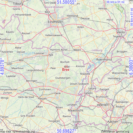
Bree GPS coordinates[2]
51° 8' 29.472" North, 5° 35' 48.84" East
| Map corner | latitude | longitude |
|---|---|---|
| Upper-left | 51.58055°, | 4.89378° |
| Center: | 51.14152°, | 5.5969° |
| Lower-right: | 50.69827°, | 6.30003° |
| Map W x H: | 98.1×98.1 km | = 61×61mi |
| max Lat: | 51.46791° ⇑15.2% North |
| Bree: | 51.14152° |
| min Lat: | ⇓84.8% South 49.53771° |
| min Long | Bree | max Long |
| 2.59368° | 5.5969° | 6.25749° |
| W 88.6%⇐ | ⇒11.4% E |
Elevation
Elevation of Bree is 48 m = 157 ft, and this is 51.5 m = 169 ft below average elevation for this country.
| Max E: |
582 m = 1909 ft | 50.9% |
| Avg. | 99.5 m = 326 ft | |
| Bree | 48 m = 157 ft | |
Min E: |
1 m = 3 ft | 49.1% |
See also: Belgium elevation on elevation.city.
Geographical zone
Bree is located in North temperate zone (between Tropic of Cancer and the Arctic Circle). Distance of this North polar circle is 1714.8 km =1065.5 mi to North.| Distance of | km | miles | from Bree |
|---|---|---|---|
| North Pole | 4320.7 | 2684.8 | to North |
| Arctic Circle | 1714.8 | 1065.5 | to North |
| Tropic Cancer | 3080.5 | 1914.1 | to South |
| Equator | 5686.4 | 3533.4 | to South |


Nearby cities:
15 places around Bree: (largest is in red/bold)
• As
14.9 km =9.3 mi,  183°
183°
• Bocholt
3.7 km =2.3 mi,  341°
341°
• Genk
20.7 km =12.9 mi,  198°
198°
• Helchteren
17.7 km =11 mi,  237°
237°
• Houthalen
19.6 km =12.2 mi,  232°
232°
• Kinrooi
10.1 km =6.3 mi,  87°
87°
• Lommel
22.1 km =13.7 mi,  296°
296°
• Maaseik
13.9 km =8.6 mi,  110°
110°
• Maasmechelen
20.7 km =12.9 mi,  160°
160°
• Neerpelt
14.4 km =8.9 mi,  311°
311°
• Opglabbeek
11 km =6.8 mi, 184°
• Overpelt
14.8 km =9.2 mi, 301°
• Peer
9.7 km =6 mi,  262°
262°
• Zonhoven
23.2 km =14.4 mi,  223°
223°
• Zutendaal
23.2 km =14.4 mi, 183°
Sources, notices
• [Note1] Compared only with cities in Belgium existing in our database
• [Src1] Map data: © OpenStreetMap contributors (CC-BY-SA)
• [Src2] Other city data from geonames.org with taken over terms of usage.
• [Src3] Geographical zone / Annual Mean Temperature by Robert A. Rohde @ Wikipedia
