Kocherinovo geodata
Kocherinovo (Kyustendil) is a populated place; located in Bulgaria in Europe/Sofia (GMT+3) time zone. With population of 2,872 people, there are 203 cities with bigger population in this country. Compared to other cities in Bulgaria, 81% of cities are located further ↑North; 90.3% of cities are located further →East and 70.7% of cities have lower elevation than Kocherinovo. Note1


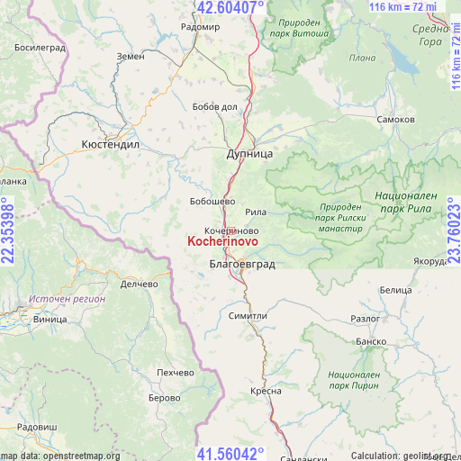
Kocherinovo GPS coordinates[2]
42° 5' 3.804" North, 23° 3' 25.56" East
| Map corner | latitude | longitude |
|---|---|---|
| Upper-left | 42.60407°, | 22.35398° |
| Center: | 42.08439°, | 23.0571° |
| Lower-right: | 41.56042°, | 23.76023° |
| Map W x H: | 116×116 km | = 72.1×72.1mi |
| max Lat: | 44.16214° ⇑81% North |
| Kocherinovo: | 42.08439° |
| min Lat: | ⇓19% South 41.32715° |
| min Long | Kocherinovo | max Long |
| 22.52139° | 23.0571° | 28.53429° |
| W 9.7%⇐ | ⇒90.3% E |
Elevation
Elevation of Kocherinovo is 407 m = 1335 ft, and this is 90.4 m = 297 ft above average elevation for this country.
| Max E: |
1221 m = 4006 ft | 29.3% |
| Kocherinovo | 407 m 1335 ft | |
| Avg. | 316.6 m = 1039 ft | |
Min E: |
1 m = 3 ft | 70.7% |
See also: Bulgaria elevation on elevation.city.
Geographical zone
Kocherinovo is located in North temperate zone (between Tropic of Cancer and the Arctic Circle). Distance of this Northern Tropic circle is 2073.4 km =1288.4 mi to South.| Distance of | km | miles | from Kocherinovo |
|---|---|---|---|
| North Pole | 5327.7 | 3310.5 | to North |
| Arctic Circle | 2721.8 | 1691.2 | to North |
| Tropic Cancer | 2073.4 | 1288.4 | to South |
| Equator | 4679.3 | 2907.6 | to South |


Nearby cities:
15 places around Kocherinovo: (largest is in red/bold)
• Belitsa
44.9 km =27.9 mi,  108°
108°
• Blagoevgrad
8.3 km =5.2 mi,  154°
154°
• Boboshevo
8.9 km =5.5 mi,  328°
328°
• Bobov Dol
31.2 km =19.4 mi,  351°
351°
• Borovets
3.9 km =2.4 mi,  307°
307°
• Dupnitsa
20.9 km =13 mi,  13°
13°
• Kresna
39.8 km =24.7 mi,  168°
168°
• Kyustendil
37.4 km =23.2 mi, 306°
• Nevestino
25.5 km =15.8 mi,  318°
318°
• Porominovo
2.5 km =1.6 mi, 110°
• Razlog
40.4 km =25.1 mi,  123°
123°
• Rila
8.3 km =5.2 mi,  49°
49°
• Sapareva Banya
28.1 km =17.5 mi,  37°
37°
• Simitli
22.9 km =14.2 mi, 167°
• Stara Kresna
33.3 km =20.7 mi,  161°
161°
Sources, notices
• [Note1] Compared only with cities in Bulgaria existing in our database
• [Src1] Map data: © OpenStreetMap contributors (CC-BY-SA)
• [Src2] Other city data from geonames.org with taken over terms of usage.
• [Src3] Geographical zone / Annual Mean Temperature by Robert A. Rohde @ Wikipedia
