Vallegrande geodata
Vallegrande (Santa Cruz) is a populated place; located in Bolivia in America/La_Paz (GMT-4) time zone. With population of 8,422 people, there are 46 cities with bigger population in this country. Compared to other cities in Bolivia, 60.9% of cities are located further ↑North; 70.2% of cities are located further ←West and 55.3% of cities have higher elevation than Vallegrande. Note1


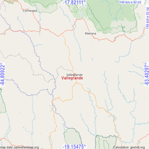
Vallegrande GPS coordinates[2]
18° 29' 21.228" South, 64° 6' 21.924" West
| Map corner | latitude | longitude |
|---|---|---|
| Upper-left | -17.82111°, | -64.80922° |
| Center: | -18.48923°, | -64.10609° |
| Lower-right: | -19.15475°, | -63.40297° |
| Map W x H: | 148.3×148.3 km | = 92.1×92.1mi |
| max Lat: | -9.71828° ⇑60.9% North |
| Vallegrande: | -18.48923° |
| min Lat: | ⇓39.1% South -22.73206° |
| min Long | Vallegrande | max Long |
| -69.14843° | -64.10609° | -57.76667° |
| W 70.2%⇐ | ⇒29.8% E |
Elevation
Elevation of Vallegrande is 2042 m = 6699 ft, and this is 30.7 m = 101 ft above average elevation for this country.
| Max E: |
4732 m = 15525 ft | 55.3% |
| Vallegrande | 2042 m 6699 ft | |
| Avg. | 2011.3 m = 6599 ft | |
Min E: |
92 m = 302 ft | 44.7% |
See also: Bolivia elevation on elevation.city.
Geographical zone
Vallegrande is located in South Torrid zone (between Equator and Tropic of Capricorn). Distance of this Southern Tropic circle is 550.1 km =341.8 mi to South.| Distance of | km | miles | from Vallegrande |
|---|---|---|---|
| Equator | 2055.8 | 1277.4 | to North |
| Tropic Capricorn | 550.1 | 341.8 | to South |
| Antarctic Circle | 5345.4 | 3321.5 | to South |
| South Pole | 7951.3 | 4940.7 | to South |


Nearby cities:
15 places around Vallegrande: (largest is in red/bold)
• Abapó
88.1 km =54.7 mi,  119°
119°
• Chuqui Chuqui
107.5 km =66.8 mi,  250°
250°
• Comarapa
78 km =48.5 mi,  324°
324°
• Jorochito
86.3 km =53.6 mi,  56°
56°
• Limoncito
89.8 km =55.8 mi, 55°
• Los Negros
110.1 km =68.4 mi,  40°
40°
• Mairana
44 km =27.3 mi,  20°
20°
• Mojocoya
62.2 km =38.6 mi,  240°
240°
• Padilla
93.4 km =58 mi,  192°
192°
• Presto
100.5 km =62.4 mi, 240°
• Samaipata
42.1 km =26.2 mi, 35°
• Santa Rita
98.8 km =61.4 mi,  53°
53°
• Santiago del Torno
94.8 km =58.9 mi, 53°
• Tomina
89.3 km =55.5 mi,  210°
210°
• Villa Serrano
74.3 km =46.2 mi,  197°
197°
Sources, notices
• [Note1] Compared only with cities in Bolivia existing in our database
• [Src1] Map data: © OpenStreetMap contributors (CC-BY-SA)
• [Src2] Other city data from geonames.org with taken over terms of usage.
• [Src3] Geographical zone / Annual Mean Temperature by Robert A. Rohde @ Wikipedia
