Mairana geodata
Mairana (Santa Cruz) is a populated place; located in Bolivia in America/La_Paz (GMT-4) time zone. With population of 4,298 people, there are 66 cities with bigger population in this country. Compared to other cities in Bolivia, 55.3% of cities are located further ↑North; 70.8% of cities are located further ←West and 60.9% of cities have higher elevation than Mairana. Note1


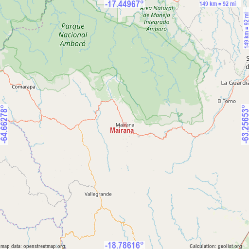
Mairana GPS coordinates[2]
18° 7' 9.084" South, 63° 57' 34.74" West
| Map corner | latitude | longitude |
|---|---|---|
| Upper-left | -17.44967°, | -64.66278° |
| Center: | -18.11919°, | -63.95965° |
| Lower-right: | -18.78616°, | -63.25653° |
| Map W x H: | 148.6×148.6 km | = 92.3×92.3mi |
| max Lat: | -9.71828° ⇑55.3% North |
| Mairana: | -18.11919° |
| min Lat: | ⇓44.7% South -22.73206° |
| min Long | Mairana | max Long |
| -69.14843° | -63.95965° | -57.76667° |
| W 70.8%⇐ | ⇒29.2% E |
Elevation
Elevation of Mairana is 1326 m = 4350 ft, and this is 685.3 m = 2248 ft below average elevation for this country.
| Max E: |
4732 m = 15525 ft | 60.9% |
| Avg. | 2011.3 m = 6599 ft | |
| Mairana | 1326 m = 4350 ft | |
Min E: |
92 m = 302 ft | 39.1% |
See also: Bolivia elevation on elevation.city.
Geographical zone
Mairana is located in South Torrid zone (between Equator and Tropic of Capricorn). Distance of this Southern Tropic circle is 591.3 km =367.4 mi to South.| Distance of | km | miles | from Mairana |
|---|---|---|---|
| Equator | 2014.7 | 1251.9 | to North |
| Tropic Capricorn | 591.3 | 367.4 | to South |
| Antarctic Circle | 5386.5 | 3347 | to South |
| South Pole | 7992.4 | 4966.2 | to South |


Nearby cities:
15 places around Mairana: (largest is in red/bold)
• Buena Vista
79.6 km =49.5 mi,  22°
22°
• Comarapa
64.6 km =40.1 mi,  290°
290°
• Jorochito
56.6 km =35.2 mi,  82°
82°
• Limoncito
59.4 km =36.9 mi, 80°
• Los Negros
70.3 km =43.7 mi,  52°
52°
• Mojocoya
100 km =62.1 mi,  224°
224°
• Samaipata
11.2 km =7 mi,  127°
127°
• San Carlos
83 km =51.6 mi, 15°
• San Juan del Surutú
75.9 km =47.2 mi, 21°
• Santa Cruz de la Sierra
90.3 km =56.1 mi,  65°
65°
• Santa Fe
100.1 km =62.2 mi, 76°
• Santa Rita
66.6 km =41.4 mi, 75°
• Santiago del Torno
62.9 km =39.1 mi, 76°
• Vallegrande
44 km =27.3 mi,  200°
200°
• Villa Yapacaní
81.1 km =50.4 mi,  9°
9°
Sources, notices
• [Note1] Compared only with cities in Bolivia existing in our database
• [Src1] Map data: © OpenStreetMap contributors (CC-BY-SA)
• [Src2] Other city data from geonames.org with taken over terms of usage.
• [Src3] Geographical zone / Annual Mean Temperature by Robert A. Rohde @ Wikipedia
