Tarija geodata
Tarija is a seat of a first-order administrative division; located in Bolivia in America/La_Paz (GMT-4) time zone. With population of 159,269 people, there are 5 cities with bigger population in this country. Compared to other cities in Bolivia, 98.1% of cities are located further ↑North; 62.1% of cities are located further ←West and 57.1% of cities have higher elevation than Tarija. Note1


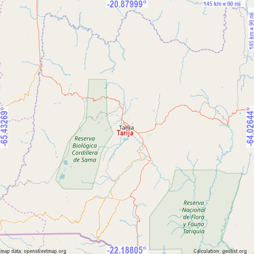
Tarija GPS coordinates[2]
21° 32' 7.764" South, 64° 43' 46.416" West
| Map corner | latitude | longitude |
|---|---|---|
| Upper-left | -20.87999°, | -65.43269° |
| Center: | -21.53549°, | -64.72956° |
| Lower-right: | -22.18805°, | -64.02644° |
| Map W x H: | 145.4×145.4 km | = 90.3×90.3mi |
| max Lat: | -9.71828° ⇑98.1% North |
| Tarija: | -21.53549° |
| min Lat: | ⇓1.9% South -22.73206° |
| min Long | Tarija | max Long |
| -69.14843° | -64.72956° | -57.76667° |
| W 62.1%⇐ | ⇒37.9% E |
Elevation
Elevation of Tarija is 1870 m = 6135 ft, and this is 141.3 m = 464 ft below average elevation for this country.
| Max E: |
4732 m = 15525 ft | 57.1% |
| Avg. | 2011.3 m = 6599 ft | |
| Tarija | 1870 m = 6135 ft | |
Min E: |
92 m = 302 ft | 42.9% |
See also: Tarija elevation on elevation.city.
Geographical zone
Tarija is located in South Torrid zone (between Equator and Tropic of Capricorn). Distance of this Southern Tropic circle is 211.4 km =131.4 mi to South.| Distance of | km | miles | from Tarija |
|---|---|---|---|
| Equator | 2394.5 | 1487.9 | to North |
| Tropic Capricorn | 211.4 | 131.4 | to South |
| Antarctic Circle | 5006.7 | 3111 | to South |
| South Pole | 7612.5 | 4730.2 | to South |


Nearby cities:
15 places around Tarija: (largest is in red/bold)
• Culpina
82.2 km =51.1 mi,  344°
344°
• Entre Ríos
57.6 km =35.8 mi,  89°
89°
• Huajlaya
105.7 km =65.7 mi,  10°
10°
• La Cueva
69.2 km =43 mi,  345°
345°
• Las Carreras
61.6 km =38.3 mi,  306°
306°
• Las Carreras
65.5 km =40.7 mi,  298°
298°
• Lintaca
106 km =65.9 mi,  323°
323°
• Pilaya
65.1 km =40.5 mi,  358°
358°
• Salitre
75.1 km =46.7 mi, 345°
• San Francisco
91.1 km =56.6 mi,  1°
1°
• San Juan
66.2 km =41.1 mi, 296°
• Santa Elena
109.7 km =68.2 mi, 357°
• Tupiza
102.9 km =63.9 mi,  275°
275°
• Villa Charcas
91.8 km =57 mi, 349°
• Villazón
108.3 km =67.3 mi,  235°
235°
Sources, notices
• [Note1] Compared only with cities in Bolivia existing in our database
• [Src1] Map data: © OpenStreetMap contributors (CC-BY-SA)
• [Src2] Other city data from geonames.org with taken over terms of usage.
• [Src3] Geographical zone / Annual Mean Temperature by Robert A. Rohde @ Wikipedia
