Santa Rosa del Sara geodata
Santa Rosa del Sara (Santa Cruz) is a populated place; located in Bolivia in America/La_Paz (GMT-4) time zone. With population of 5,251 people, there are 56 cities with bigger population in this country. Compared to other cities in Bolivia, 76.4% of cities are located further ↓South; 77% of cities are located further ←West and 87.6% of cities have higher elevation than Santa Rosa del Sara. Note1


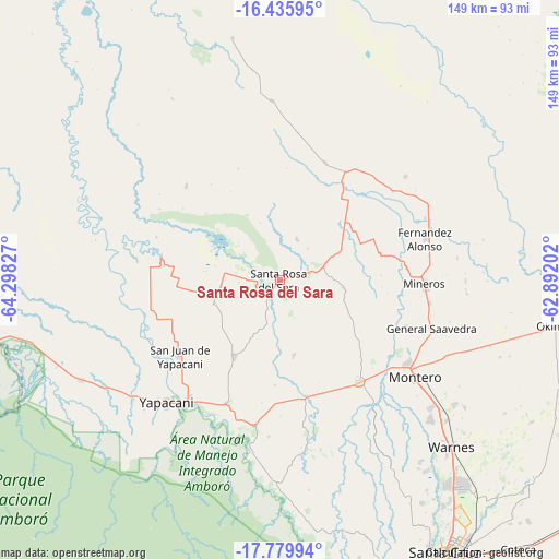
Santa Rosa del Sara GPS coordinates[2]
17° 6' 32.976" South, 63° 35' 42.504" West
| Map corner | latitude | longitude |
|---|---|---|
| Upper-left | -16.43595°, | -64.29827° |
| Center: | -17.10916°, | -63.59514° |
| Lower-right: | -17.77994°, | -62.89202° |
| Map W x H: | 149.4×149.4 km | = 92.8×92.8mi |
| max Lat: | -9.71828° ⇑23.6% North |
| Santa Rosa del Sara: | -17.10916° |
| min Lat: | ⇓76.4% South -22.73206° |
| min Long | Santa Rosa del | max Long |
| -69.14843° | -63.59514° | -57.76667° |
| W 77%⇐ | ⇒23% E |
Elevation
Elevation of Santa Rosa del Sara is 271 m = 889 ft, and this is 1740.3 m = 5710 ft below average elevation for this country.
| Max E: |
4732 m = 15525 ft | 87.6% |
| Avg. | 2011.3 m = 6599 ft | |
| Santa Rosa del Sara | 271 m = 889 ft | |
Min E: |
92 m = 302 ft | 12.4% |
See also: Bolivia elevation on elevation.city.
Geographical zone
Santa Rosa del Sara is located in South Torrid zone (between Equator and Tropic of Capricorn). Distance of this Southern Tropic circle is 703.6 km =437.2 mi to South.| Distance of | km | miles | from Santa Rosa del Sara |
|---|---|---|---|
| Equator | 1902.4 | 1182.1 | to North |
| Tropic Capricorn | 703.6 | 437.2 | to South |
| Antarctic Circle | 5498.8 | 3416.8 | to South |
| South Pole | 8104.7 | 5036 | to South |


Nearby cities:
15 places around Santa Rosa del Sara: (largest is in red/bold)
• Buena Vista
39.7 km =24.7 mi,  191°
191°
• Cotoca
97.6 km =60.6 mi,  143°
143°
• La Bélgica
63.4 km =39.4 mi, 140°
• Los Negros
71.5 km =44.4 mi,  166°
166°
• Mineros
38.7 km =24 mi,  91°
91°
• Montero
44.6 km =27.7 mi,  124°
124°
• Okinawa Número Uno
83.8 km =52.1 mi,  99°
99°
• Portachuelo
34.5 km =21.4 mi, 141°
• San Carlos
36.3 km =22.6 mi,  206°
206°
• San Juan del Surutú
43.1 km =26.8 mi, 194°
• Santa Cruz de la Sierra
87.2 km =54.2 mi,  149°
149°
• Santa Rita
98.8 km =61.4 mi,  164°
164°
• Santiago del Torno
100.2 km =62.3 mi, 166°
• Villa Yapacaní
41.1 km =25.5 mi,  218°
218°
• Warnes
64.1 km =39.8 mi,  134°
134°
Sources, notices
• [Note1] Compared only with cities in Bolivia existing in our database
• [Src1] Map data: © OpenStreetMap contributors (CC-BY-SA)
• [Src2] Other city data from geonames.org with taken over terms of usage.
• [Src3] Geographical zone / Annual Mean Temperature by Robert A. Rohde @ Wikipedia
