Rosario del Ingre geodata
Rosario del Ingre (Chuquisaca) is a seat of a fourth-order administrative division; located in Bolivia in America/La_Paz (GMT-4) time zone. In our database, there are 117 cities with bigger population. Compared to other cities in Bolivia, 85.7% of cities are located further ↑North; 72% of cities are located further ←West and 63.4% of cities have higher elevation than Rosario del Ingre. Note1
Administrative division(s):
- Level 1: Chuquisaca
- Level 2: Provincia Hernando Siles
- Level 3: Huacareta
- Level 4: Rosario del Ingre


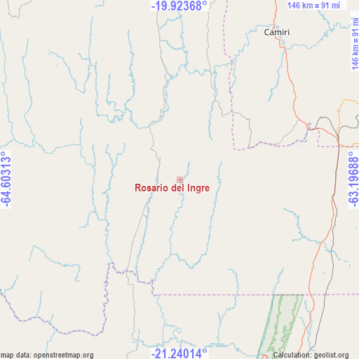
Rosario del Ingre GPS coordinates[2]
20° 34' 59.988" South, 63° 54' 0" West
| Map corner | latitude | longitude |
|---|---|---|
| Upper-left | -19.92368°, | -64.60313° |
| Center: | -20.58333°, | -63.9° |
| Lower-right: | -21.24014°, | -63.19688° |
| Map W x H: | 146.4×146.4 km | = 91×91mi |
| max Lat: | -9.71828° ⇑85.7% North |
| Rosario del Ingre: | -20.58333° |
| min Lat: | ⇓14.3% South -22.73206° |
| min Long | Rosario del Ing | max Long |
| -69.14843° | -63.9° | -57.76667° |
| W 72%⇐ | ⇒28% E |
Elevation
Elevation of Rosario del Ingre is 936 m = 3071 ft, and this is 1075.3 m = 3528 ft below average elevation for this country.
| Max E: |
4732 m = 15525 ft | 63.4% |
| Avg. | 2011.3 m = 6599 ft | |
| Rosario del Ingre | 936 m = 3071 ft | |
Min E: |
92 m = 302 ft | 36.6% |
See also: Bolivia elevation on elevation.city.
Geographical zone
Rosario del Ingre is located in South Torrid zone (between Equator and Tropic of Capricorn). Distance of this Southern Tropic circle is 317.3 km =197.2 mi to South.| Distance of | km | miles | from Rosario del Ingre |
|---|---|---|---|
| Equator | 2288.7 | 1422.1 | to North |
| Tropic Capricorn | 317.3 | 197.2 | to South |
| Antarctic Circle | 5112.5 | 3176.8 | to South |
| South Pole | 7718.4 | 4796 | to South |


Nearby cities:
15 places around Rosario del Ingre: (largest is in red/bold)
• Azurduy
75.4 km =46.9 mi,  314°
314°
• Boyuibe
66.6 km =41.4 mi,  75°
75°
• Camatindi
65.8 km =40.9 mi,  132°
132°
• Camiri
72.5 km =45 mi,  33°
33°
• Carandayti
88.7 km =55.1 mi,  102°
102°
• Entre Ríos
108.6 km =67.5 mi,  195°
195°
• Huajlaya
67.7 km =42.1 mi,  268°
268°
• Monteagudo
87.3 km =54.2 mi,  356°
356°
• Pilaya
97.3 km =60.5 mi,  245°
245°
• Salitre
110.9 km =68.9 mi, 252°
• San Francisco
84.5 km =52.5 mi,  259°
259°
• Santa Elena
92 km =57.2 mi, 272°
• Sapirangui
73.3 km =45.5 mi,  9°
9°
• Villa Charcas
103.6 km =64.4 mi, 261°
• Villamontes
87.8 km =54.6 mi,  149°
149°
Sources, notices
• [Note1] Compared only with cities in Bolivia existing in our database
• [Src1] Map data: © OpenStreetMap contributors (CC-BY-SA)
• [Src2] Other city data from geonames.org with taken over terms of usage.
• [Src3] Geographical zone / Annual Mean Temperature by Robert A. Rohde @ Wikipedia
