Boyuibe geodata
Boyuibe (Santa Cruz) is a populated place; located in Bolivia in America/La_Paz (GMT-4) time zone. With population of 3,075 people, there are 81 cities with bigger population in this country. Compared to other cities in Bolivia, 83.9% of cities are located further ↑North; 83.9% of cities are located further ←West and 64.6% of cities have higher elevation than Boyuibe. Note1


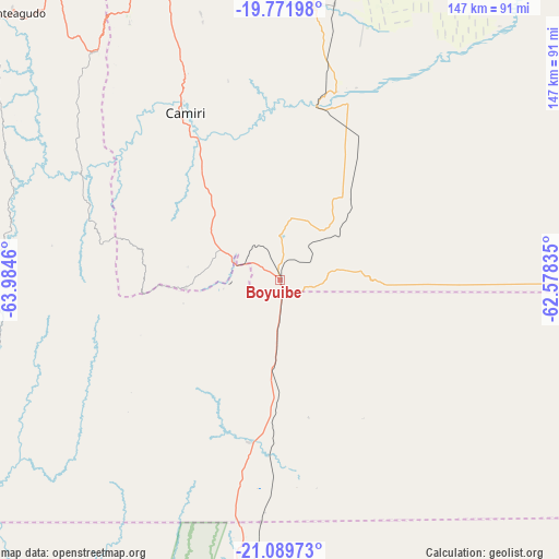
Boyuibe GPS coordinates[2]
20° 25' 56.172" South, 63° 16' 53.292" West
| Map corner | latitude | longitude |
|---|---|---|
| Upper-left | -19.77198°, | -63.9846° |
| Center: | -20.43227°, | -63.28147° |
| Lower-right: | -21.08973°, | -62.57835° |
| Map W x H: | 146.5×146.5 km | = 91×91mi |
| max Lat: | -9.71828° ⇑83.9% North |
| Boyuibe: | -20.43227° |
| min Lat: | ⇓16.1% South -22.73206° |
| min Long | Boyuibe | max Long |
| -69.14843° | -63.28147° | -57.76667° |
| W 83.9%⇐ | ⇒16.1% E |
Elevation
Elevation of Boyuibe is 811 m = 2661 ft, and this is 1200.3 m = 3938 ft below average elevation for this country.
| Max E: |
4732 m = 15525 ft | 64.6% |
| Avg. | 2011.3 m = 6599 ft | |
| Boyuibe | 811 m = 2661 ft | |
Min E: |
92 m = 302 ft | 35.4% |
See also: Bolivia elevation on elevation.city.
Geographical zone
Boyuibe is located in South Torrid zone (between Equator and Tropic of Capricorn). Distance of this Southern Tropic circle is 334.1 km =207.6 mi to South.| Distance of | km | miles | from Boyuibe |
|---|---|---|---|
| Equator | 2271.9 | 1411.7 | to North |
| Tropic Capricorn | 334.1 | 207.6 | to South |
| Antarctic Circle | 5129.3 | 3187.2 | to South |
| South Pole | 7735.2 | 4806.4 | to South |


Nearby cities:
15 places around Boyuibe: (largest is in red/bold)
• Azurduy
123.6 km =76.8 mi,  287°
287°
• Camatindi
63.3 km =39.3 mi,  194°
194°
• Camiri
50.3 km =31.3 mi,  330°
330°
• Carandayti
41.8 km =26 mi,  147°
147°
• Charagua
71.8 km =44.6 mi,  6°
6°
• Entre Ríos
152.9 km =95 mi,  217°
217°
• Huajlaya
133.4 km =82.9 mi,  261°
261°
• Monteagudo
99.4 km =61.8 mi,  315°
315°
• Pilaya
163.2 km =101.4 mi,  249°
249°
• Rosario del Ingre
66.6 km =41.4 mi, 255°
• San Francisco
151 km =93.8 mi, 257°
• San Pedro
156.3 km =97.1 mi,  305°
305°
• Santa Elena
157 km =97.6 mi,  265°
265°
• Sapirangui
76.3 km =47.4 mi, 316°
• Villamontes
94.3 km =58.6 mi, 191°
Sources, notices
• [Note1] Compared only with cities in Bolivia existing in our database
• [Src1] Map data: © OpenStreetMap contributors (CC-BY-SA)
• [Src2] Other city data from geonames.org with taken over terms of usage.
• [Src3] Geographical zone / Annual Mean Temperature by Robert A. Rohde @ Wikipedia
