Camiri geodata
Camiri (Santa Cruz) is a populated place; located in Bolivia in America/La_Paz (GMT-4) time zone. With population of 27,961 people, there are 19 cities with bigger population in this country. Compared to other cities in Bolivia, 82% of cities are located further ↑North; 77.6% of cities are located further ←West and 65.8% of cities have higher elevation than Camiri. Note1


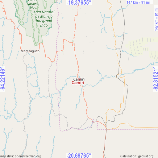
Camiri GPS coordinates[2]
20° 2' 18.564" South, 63° 31' 5.988" West
| Map corner | latitude | longitude |
|---|---|---|
| Upper-left | -19.37655°, | -64.22146° |
| Center: | -20.03849°, | -63.51833° |
| Lower-right: | -20.69765°, | -62.81521° |
| Map W x H: | 146.9×146.9 km | = 91.3×91.3mi |
| max Lat: | -9.71828° ⇑82% North |
| Camiri: | -20.03849° |
| min Lat: | ⇓18% South -22.73206° |
| min Long | Camiri | max Long |
| -69.14843° | -63.51833° | -57.76667° |
| W 77.6%⇐ | ⇒22.4% E |
Elevation
Elevation of Camiri is 802 m = 2631 ft, and this is 1209.3 m = 3968 ft below average elevation for this country.
| Max E: |
4732 m = 15525 ft | 65.8% |
| Avg. | 2011.3 m = 6599 ft | |
| Camiri | 802 m = 2631 ft | |
Min E: |
92 m = 302 ft | 34.2% |
See also: Bolivia elevation on elevation.city.
Geographical zone
Camiri is located in South Torrid zone (between Equator and Tropic of Capricorn). Distance of this Southern Tropic circle is 377.8 km =234.8 mi to South.| Distance of | km | miles | from Camiri |
|---|---|---|---|
| Equator | 2228.1 | 1384.5 | to North |
| Tropic Capricorn | 377.8 | 234.8 | to South |
| Antarctic Circle | 5173.1 | 3214.4 | to South |
| South Pole | 7779 | 4833.6 | to South |


Nearby cities:
15 places around Camiri: (largest is in red/bold)
• Abapó
129.3 km =80.3 mi,  6°
6°
• Azurduy
93.8 km =58.3 mi,  265°
265°
• Boyuibe
50.3 km =31.3 mi,  150°
150°
• Camatindi
105.4 km =65.5 mi,  175°
175°
• Carandayti
92.1 km =57.2 mi, 149°
• Charagua
43.3 km =26.9 mi,  50°
50°
• Huajlaya
124.4 km =77.3 mi,  239°
239°
• Monteagudo
52.8 km =32.8 mi,  300°
300°
• Padilla
115.4 km =71.7 mi,  314°
314°
• Rosario del Ingre
72.5 km =45 mi,  213°
213°
• San Pedro
112.9 km =70.2 mi,  294°
294°
• Sapirangui
30.1 km =18.7 mi, 292°
• Tomina
142.6 km =88.6 mi, 311°
• Villa Serrano
132 km =82 mi,  320°
320°
• Villamontes
136.2 km =84.6 mi, 177°
Sources, notices
• [Note1] Compared only with cities in Bolivia existing in our database
• [Src1] Map data: © OpenStreetMap contributors (CC-BY-SA)
• [Src2] Other city data from geonames.org with taken over terms of usage.
• [Src3] Geographical zone / Annual Mean Temperature by Robert A. Rohde @ Wikipedia
