Ascensión geodata
Ascensión (Santa Cruz) is a populated place; located in Bolivia in America/La_Paz (GMT-4) time zone. With population of 14,429 people, there are 33 cities with bigger population in this country. Compared to other cities in Bolivia, 90.1% of cities are located further ↓South; 88.8% of cities are located further ←West and 92.5% of cities have higher elevation than Ascensión. Note1


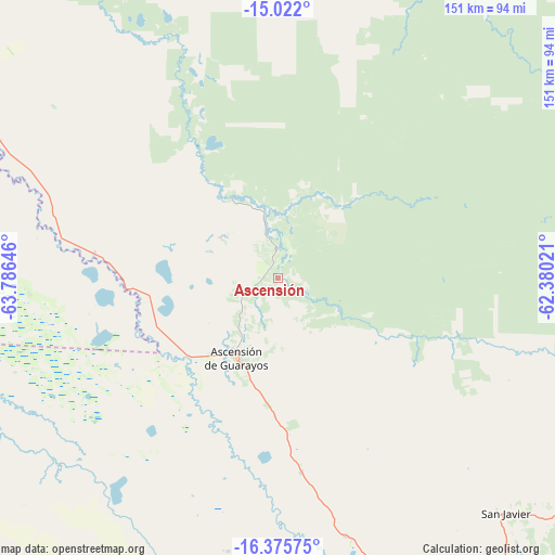
Ascensión GPS coordinates[2]
15° 42' 0" South, 63° 4' 59.988" West
| Map corner | latitude | longitude |
|---|---|---|
| Upper-left | -15.022°, | -63.78646° |
| Center: | -15.7°, | -63.08333° |
| Lower-right: | -16.37575°, | -62.38021° |
| Map W x H: | 150.5×150.5 km | = 93.5×93.5mi |
| max Lat: | -9.71828° ⇑9.9% North |
| Ascensión: | -15.7° |
| min Lat: | ⇓90.1% South -22.73206° |
| min Long | Ascensión | max Long |
| -69.14843° | -63.08333° | -57.76667° |
| W 88.8%⇐ | ⇒11.2% E |
Elevation
Elevation of Ascensión is 198 m = 650 ft, and this is 1813.3 m = 5949 ft below average elevation for this country.
| Max E: |
4732 m = 15525 ft | 92.5% |
| Avg. | 2011.3 m = 6599 ft | |
| Ascensión | 198 m = 650 ft | |
Min E: |
92 m = 302 ft | 7.5% |
See also: Bolivia elevation on elevation.city.
Geographical zone
Ascensión is located in South Torrid zone (between Equator and Tropic of Capricorn). Distance of this Southern Tropic circle is 860.2 km =534.5 mi to South.| Distance of | km | miles | from Ascensión |
|---|---|---|---|
| Equator | 1745.7 | 1084.7 | to North |
| Tropic Capricorn | 860.2 | 534.5 | to South |
| Antarctic Circle | 5655.5 | 3514.2 | to South |
| South Pole | 8261.4 | 5133.4 | to South |


Nearby cities:
15 places around Ascensión: (largest is in red/bold)
• Ascención de Guarayos
24.2 km =15 mi,  207°
207°
• Buena Vista
205.3 km =127.6 mi,  197°
197°
• La Bélgica
206.2 km =128.1 mi,  183°
183°
• Mineros
158.5 km =98.5 mi,  185°
185°
• Montero
183.1 km =113.8 mi, 185°
• Okinawa Número Uno
172.8 km =107.4 mi,  170°
170°
• Portachuelo
186.6 km =115.9 mi, 190°
• Puesto de Pailas
218.9 km =136 mi, 172°
• San Carlos
201.9 km =125.5 mi, 200°
• San Juan del Surutú
208.9 km =129.8 mi, 198°
• Santa Rosa del Sara
165.9 km =103.1 mi, 199°
• Trinidad
217.4 km =135.1 mi,  296°
296°
• Urubichá
37.2 km =23.1 mi,  23°
23°
• Villa Yapacaní
205.2 km =127.5 mi, 202°
• Warnes
202.2 km =125.6 mi, 182°
Sources, notices
• [Note1] Compared only with cities in Bolivia existing in our database
• [Src1] Map data: © OpenStreetMap contributors (CC-BY-SA)
• [Src2] Other city data from geonames.org with taken over terms of usage.
• [Src3] Geographical zone / Annual Mean Temperature by Robert A. Rohde @ Wikipedia
